Zirun geodata
Zirun (Shanxi) is a seat of a fourth-order administrative division; located in China in Asia/Shanghai (GMT+8) time zone. In our database, there are 1268 cities with bigger population. Compared to other cities in China, 84.1% of cities are located further ↓South; 59.2% of cities are located further →East and 85.9% of cities have lower elevation than Zirun. Note1


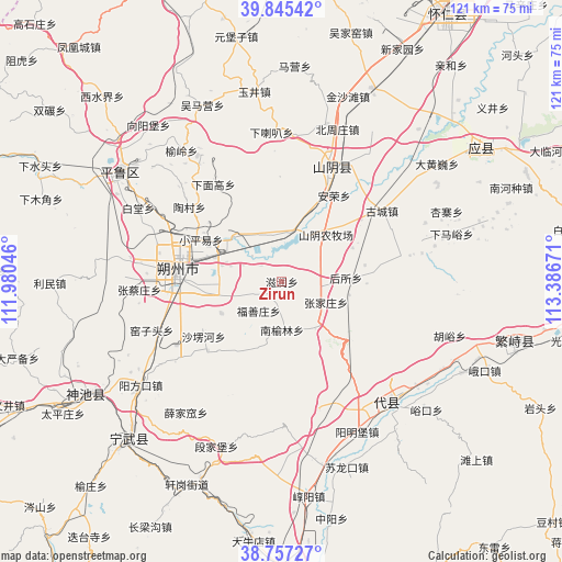
Zirun GPS coordinates[2]
39° 18' 12.456" North, 112° 41' 0.888" East
| Map corner | latitude | longitude |
|---|---|---|
| Upper-left | 39.84542°, | 111.98046° |
| Center: | 39.30346°, | 112.68358° |
| Lower-right: | 38.75727°, | 113.38671° |
| Map W x H: | 121×121 km | = 75.2×75.2mi |
| max Lat: | 53.31946° ⇑15.9% North |
| Zirun: | 39.30346° |
| min Lat: | ⇓84.1% South 18.22056° |
| min Long | Zirun | max Long |
| 75.07348° | 112.68358° | 134.28917° |
| W 40.8%⇐ | ⇒59.2% E |
Elevation
Elevation of Zirun is 1041 m = 3415 ft, and this is 556.2 m = 1825 ft above average elevation for this country.
| Max E: |
5622 m = 18445 ft | 14.1% |
| Zirun | 1041 m 3415 ft | |
| Avg. | 484.8 m = 1591 ft | |
Min E: |
-3 m = -10 ft | 85.9% |
See also: China elevation on elevation.city.
Geographical zone
Zirun is located in North temperate zone (between Tropic of Cancer and the Arctic Circle). Distance of this Northern Tropic circle is 1764.2 km =1096.2 mi to South.| Distance of | km | miles | from Zirun |
|---|---|---|---|
| North Pole | 5636.9 | 3502.6 | to North |
| Arctic Circle | 3031 | 1883.4 | to North |
| Tropic Cancer | 1764.2 | 1096.2 | to South |
| Equator | 4370.1 | 2715.5 | to South |


Nearby cities:
15 places around Zirun: (largest is in red/bold)
• Anrong
21.7 km =13.5 mi,  31°
31°
• Dongshentou
12.8 km =8 mi,  316°
316°
• Fushanzhuang
8 km =5 mi,  218°
218°
• Gucheng
26.4 km =16.4 mi,  54°
54°
• Housuo
13.8 km =8.6 mi,  86°
86°
• Jiazhuang
14.7 km =9.1 mi,  242°
242°
• Nanyulinxi
10.5 km =6.5 mi,  181°
181°
• Shangshaleng
20.5 km =12.7 mi, 235°
• Shuozhou
22.5 km =14 mi,  273°
273°
• Taocun
25.5 km =15.8 mi,  308°
308°
• Xiamiangao
26.1 km =16.2 mi,  325°
325°
• Xiaopingyi
19.6 km =12.2 mi,  297°
297°
• Xuekulue
15.2 km =9.4 mi,  39°
39°
• Yanmenguan
19.7 km =12.2 mi,  129°
129°
• Zhangjiazhuang
10.5 km =6.5 mi,  115°
115°
Sources, notices
• [Note1] Compared only with cities in China existing in our database
• [Src1] Map data: © OpenStreetMap contributors (CC-BY-SA)
• [Src2] Other city data from geonames.org with taken over terms of usage.
• [Src3] Geographical zone / Annual Mean Temperature by Robert A. Rohde @ Wikipedia
