Fenghuanglu geodata
Fenghuanglu (Jiangsu) is a seat of a fourth-order administrative division; located in China in Asia/Shanghai (GMT+8) time zone. In our database, there are 1268 cities with bigger population. Compared to other cities in China, 63.7% of cities are located further ↓South; 81.7% of cities are located further ←West and 94.3% of cities have higher elevation than Fenghuanglu. Note1


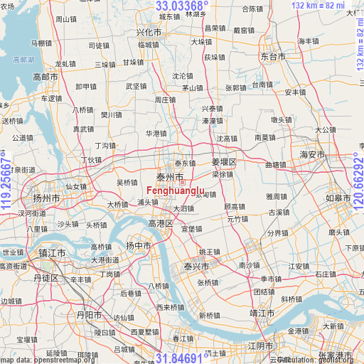
Fenghuanglu GPS coordinates[2]
32° 26' 32.1" North, 119° 57' 35.244" East
| Map corner | latitude | longitude |
|---|---|---|
| Upper-left | 33.03368°, | 119.25667° |
| Center: | 32.44225°, | 119.95979° |
| Lower-right: | 31.84691°, | 120.66292° |
| Map W x H: | 132×132 km | = 82×82mi |
| max Lat: | 53.31946° ⇑36.3% North |
| Fenghuanglu: | 32.44225° |
| min Lat: | ⇓63.7% South 18.22056° |
| min Long | Fenghuanglu | max Long |
| 75.07348° | 119.95979° | 134.28917° |
| W 81.7%⇐ | ⇒18.3% E |
Elevation
Elevation of Fenghuanglu is 7 m = 23 ft, and this is 477.8 m = 1568 ft below average elevation for this country.
| Max E: |
5622 m = 18445 ft | 94.3% |
| Avg. | 484.8 m = 1591 ft | |
| Fenghuanglu | 7 m = 23 ft | |
Min E: |
-3 m = -10 ft | 5.7% |
See also: China elevation on elevation.city.
Geographical zone
Fenghuanglu is located in North temperate zone (between Tropic of Cancer and the Arctic Circle). Distance of this Northern Tropic circle is 1001.3 km =622.2 mi to South.| Distance of | km | miles | from Fenghuanglu |
|---|---|---|---|
| North Pole | 6399.8 | 3976.7 | to North |
| Arctic Circle | 3793.9 | 2357.4 | to North |
| Tropic Cancer | 1001.3 | 622.2 | to South |
| Equator | 3607.2 | 2241.4 | to South |


Nearby cities:
15 places around Fenghuanglu: (largest is in red/bold)
• Chengbei
8 km =5 mi,  329°
329°
• Chengdong
7.2 km =4.5 mi, 331°
• Chengnan
5 km =3.1 mi,  307°
307°
• Chengxi
8.6 km =5.3 mi, 312°
• Chengzhong
6.2 km =3.9 mi,  315°
315°
• Dasi
9.4 km =5.8 mi,  174°
174°
• Dongjiao
7.2 km =4.5 mi,  340°
340°
• Huzhuang
11.6 km =7.2 mi,  150°
150°
• Jingtailu
7 km =4.3 mi,  9°
9°
• Sixiang
7.7 km =4.8 mi,  245°
245°
• Suchen
8.7 km =5.4 mi,  35°
35°
• Taizhou
7.2 km =4.5 mi, 318°
• Xuzhuang
10.8 km =6.7 mi,  207°
207°
• Yexu
6.1 km =3.8 mi, 208°
• Zhangdian
9.6 km =6 mi,  116°
116°
Sources, notices
• [Note1] Compared only with cities in China existing in our database
• [Src1] Map data: © OpenStreetMap contributors (CC-BY-SA)
• [Src2] Other city data from geonames.org with taken over terms of usage.
• [Src3] Geographical zone / Annual Mean Temperature by Robert A. Rohde @ Wikipedia
