Suchen geodata
Suchen (Jiangsu) is a seat of a fourth-order administrative division; located in China in Asia/Shanghai (GMT+8) time zone. In our database, there are 1268 cities with bigger population. Compared to other cities in China, 64% of cities are located further ↓South; 82% of cities are located further ←West and 97.2% of cities have higher elevation than Suchen. Note1


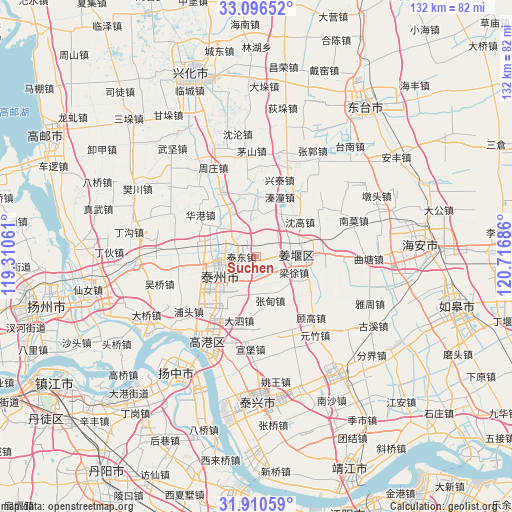
Suchen GPS coordinates[2]
32° 30' 19.836" North, 120° 0' 49.428" East
| Map corner | latitude | longitude |
|---|---|---|
| Upper-left | 33.09652°, | 119.31061° |
| Center: | 32.50551°, | 120.01373° |
| Lower-right: | 31.91059°, | 120.71686° |
| Map W x H: | 131.9×131.9 km | = 82×82mi |
| max Lat: | 53.31946° ⇑36% North |
| Suchen: | 32.50551° |
| min Lat: | ⇓64% South 18.22056° |
| min Long | Suchen | max Long |
| 75.07348° | 120.01373° | 134.28917° |
| W 82%⇐ | ⇒18% E |
Elevation
Elevation of Suchen is 5 m = 16 ft, and this is 479.8 m = 1574 ft below average elevation for this country.
| Max E: |
5622 m = 18445 ft | 97.2% |
| Avg. | 484.8 m = 1591 ft | |
| Suchen | 5 m = 16 ft | |
Min E: |
-3 m = -10 ft | 2.8% |
See also: China elevation on elevation.city.
Geographical zone
Suchen is located in North temperate zone (between Tropic of Cancer and the Arctic Circle). Distance of this Northern Tropic circle is 1008.4 km =626.6 mi to South.| Distance of | km | miles | from Suchen |
|---|---|---|---|
| North Pole | 6392.8 | 3972.3 | to North |
| Arctic Circle | 3786.9 | 2353.1 | to North |
| Tropic Cancer | 1008.4 | 626.6 | to South |
| Equator | 3614.3 | 2245.8 | to South |


Nearby cities:
15 places around Suchen: (largest is in red/bold)
• Chengbei
9.1 km =5.7 mi,  268°
268°
• Chengdong
8.5 km =5.3 mi, 265°
• Chengnan
9.8 km =6.1 mi,  246°
246°
• Chengxi
11.4 km =7.1 mi,  263°
263°
• Chengzhong
9.8 km =6.1 mi, 254°
• Dongjiao
7.5 km =4.7 mi, 267°
• Fenghuanglu
8.7 km =5.4 mi,  215°
215°
• Jiangyan
12.1 km =7.5 mi,  89°
89°
• Jingtailu
3.9 km =2.4 mi, 268°
• Liangxu
10.2 km =6.3 mi,  112°
112°
• Qiaotou
7.2 km =4.5 mi,  46°
46°
• Shengao
14.4 km =8.9 mi, 51°
• Taizhou
10 km =6.2 mi, 260°
• Yuxi
8.6 km =5.3 mi,  350°
350°
• Zhangdian
11.8 km =7.3 mi,  162°
162°
Sources, notices
• [Note1] Compared only with cities in China existing in our database
• [Src1] Map data: © OpenStreetMap contributors (CC-BY-SA)
• [Src2] Other city data from geonames.org with taken over terms of usage.
• [Src3] Geographical zone / Annual Mean Temperature by Robert A. Rohde @ Wikipedia
