Sixiang geodata
Sixiang (Jiangsu) is a seat of a fourth-order administrative division; located in China in Asia/Shanghai (GMT+8) time zone. In our database, there are 1268 cities with bigger population. Compared to other cities in China, 63.6% of cities are located further ↓South; 81.1% of cities are located further ←West and 92.7% of cities have higher elevation than Sixiang. Note1


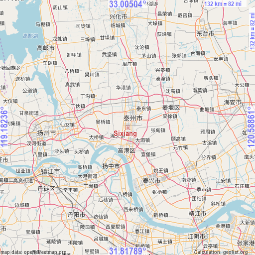
Sixiang GPS coordinates[2]
32° 24' 48.312" North, 119° 53' 7.728" East
| Map corner | latitude | longitude |
|---|---|---|
| Upper-left | 33.00504°, | 119.18236° |
| Center: | 32.41342°, | 119.88548° |
| Lower-right: | 31.81789°, | 120.58861° |
| Map W x H: | 132×132 km | = 82×82mi |
| max Lat: | 53.31946° ⇑36.4% North |
| Sixiang: | 32.41342° |
| min Lat: | ⇓63.6% South 18.22056° |
| min Long | Sixiang | max Long |
| 75.07348° | 119.88548° | 134.28917° |
| W 81.1%⇐ | ⇒18.9% E |
Elevation
Elevation of Sixiang is 8 m = 26 ft, and this is 476.8 m = 1564 ft below average elevation for this country.
| Max E: |
5622 m = 18445 ft | 92.7% |
| Avg. | 484.8 m = 1591 ft | |
| Sixiang | 8 m = 26 ft | |
Min E: |
-3 m = -10 ft | 7.3% |
See also: China elevation on elevation.city.
Geographical zone
Sixiang is located in North temperate zone (between Tropic of Cancer and the Arctic Circle). Distance of this Northern Tropic circle is 998.1 km =620.2 mi to South.| Distance of | km | miles | from Sixiang |
|---|---|---|---|
| North Pole | 6403 | 3978.6 | to North |
| Arctic Circle | 3797.1 | 2359.4 | to North |
| Tropic Cancer | 998.1 | 620.2 | to South |
| Equator | 3604 | 2239.4 | to South |


Nearby cities:
15 places around Sixiang: (largest is in red/bold)
• Chengbei
10.5 km =6.5 mi,  16°
16°
• Chengdong
10.2 km =6.3 mi, 20°
• Chengnan
7 km =4.3 mi,  25°
25°
• Chengxi
9 km =5.6 mi,  4°
4°
• Chengzhong
8.1 km =5 mi, 18°
• Dasi
10 km =6.2 mi,  127°
127°
• Diaopu
7.4 km =4.6 mi,  187°
187°
• Dongjiao
10.9 km =6.8 mi, 24°
• Fenghuanglu
7.7 km =4.8 mi,  65°
65°
• Jiulong
9.1 km =5.7 mi,  334°
334°
• Kou’an
11.7 km =7.3 mi,  184°
184°
• Putou
6.4 km =4 mi,  236°
236°
• Taizhou
8.9 km =5.5 mi,  13°
13°
• Xuzhuang
6.7 km =4.2 mi,  162°
162°
• Yexu
4.6 km =2.9 mi,  118°
118°
Sources, notices
• [Note1] Compared only with cities in China existing in our database
• [Src1] Map data: © OpenStreetMap contributors (CC-BY-SA)
• [Src2] Other city data from geonames.org with taken over terms of usage.
• [Src3] Geographical zone / Annual Mean Temperature by Robert A. Rohde @ Wikipedia
