Tanghua geodata
Tanghua (Hunan) is a seat of a fourth-order administrative division; located in China in Asia/Shanghai (GMT+8) time zone. In our database, there are 1268 cities with bigger population. Compared to other cities in China, 61.1% of cities are located further ↑North; 63.3% of cities are located further →East and 75.3% of cities have higher elevation than Tanghua. Note1


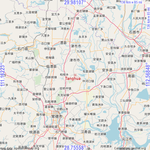
Tanghua GPS coordinates[2]
29° 22' 12.612" North, 111° 51' 55.26" East
| Map corner | latitude | longitude |
|---|---|---|
| Upper-left | 29.98107°, | 111.16223° |
| Center: | 29.37017°, | 111.86535° |
| Lower-right: | 28.75558°, | 112.56848° |
| Map W x H: | 136.3×136.3 km | = 84.7×84.7mi |
| max Lat: | 53.31946° ⇑61.1% North |
| Tanghua: | 29.37017° |
| min Lat: | ⇓38.9% South 18.22056° |
| min Long | Tanghua | max Long |
| 75.07348° | 111.86535° | 134.28917° |
| W 36.7%⇐ | ⇒63.3% E |
Elevation
Elevation of Tanghua is 36 m = 118 ft, and this is 448.8 m = 1472 ft below average elevation for this country.
| Max E: |
5622 m = 18445 ft | 75.3% |
| Avg. | 484.8 m = 1591 ft | |
| Tanghua | 36 m = 118 ft | |
Min E: |
-3 m = -10 ft | 24.7% |
See also: China elevation on elevation.city.
Geographical zone
Tanghua is located in North temperate zone (between Tropic of Cancer and the Arctic Circle). Distance of this Northern Tropic circle is 659.7 km =409.9 mi to South.| Distance of | km | miles | from Tanghua |
|---|---|---|---|
| North Pole | 6741.4 | 4188.9 | to North |
| Arctic Circle | 4135.5 | 2569.7 | to North |
| Tropic Cancer | 659.7 | 409.9 | to South |
| Equator | 3265.7 | 2029.2 | to South |


Nearby cities:
15 places around Tanghua: (largest is in red/bold)
• Anfeng
20.2 km =12.6 mi,  74°
74°
• Baiyi
9.6 km =6 mi,  4°
4°
• Baizhi
10.2 km =6.3 mi,  273°
273°
• Baohedi
12.7 km =7.9 mi, 72°
• Dalongzhan
21.4 km =13.3 mi,  210°
210°
• Dukou
8.2 km =5.1 mi,  123°
123°
• Fenghuo
15.1 km =9.4 mi,  310°
310°
• Lijiapu
15 km =9.3 mi,  20°
20°
• Lingquan
18 km =11.2 mi,  347°
347°
• Shigongqiao
20.8 km =12.9 mi,  179°
179°
• Shuangqiaoping
14.6 km =9.1 mi,  217°
217°
• Xinzhou
20.6 km =12.8 mi, 4°
• Zhonghekou
13 km =8.1 mi,  114°
114°
• Zhoujiadian
14 km =8.7 mi,  166°
166°
• Zhufeng
20.6 km =12.8 mi,  149°
149°
Sources, notices
• [Note1] Compared only with cities in China existing in our database
• [Src1] Map data: © OpenStreetMap contributors (CC-BY-SA)
• [Src2] Other city data from geonames.org with taken over terms of usage.
• [Src3] Geographical zone / Annual Mean Temperature by Robert A. Rohde @ Wikipedia
