Taiyang geodata
Taiyang (Jiangxi) is a seat of a fourth-order administrative division; located in China in Asia/Shanghai (GMT+8) time zone. In our database, there are 1268 cities with bigger population. Compared to other cities in China, 72.5% of cities are located further ↑North; 55.7% of cities are located further ←West and 75.3% of cities have higher elevation than Taiyang. Note1


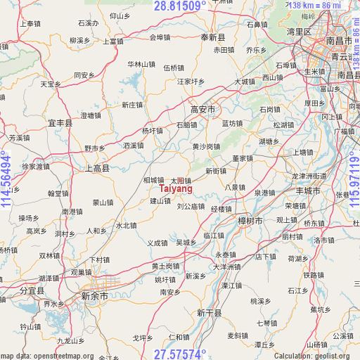
Taiyang GPS coordinates[2]
28° 11' 49.956" North, 115° 16' 5.016" East
| Map corner | latitude | longitude |
|---|---|---|
| Upper-left | 28.81509°, | 114.56494° |
| Center: | 28.19721°, | 115.26806° |
| Lower-right: | 27.57574°, | 115.97119° |
| Map W x H: | 137.8×137.8 km | = 85.6×85.6mi |
| max Lat: | 53.31946° ⇑72.5% North |
| Taiyang: | 28.19721° |
| min Lat: | ⇓27.5% South 18.22056° |
| min Long | Taiyang | max Long |
| 75.07348° | 115.26806° | 134.28917° |
| W 55.7%⇐ | ⇒44.3% E |
Elevation
Elevation of Taiyang is 36 m = 118 ft, and this is 448.8 m = 1472 ft below average elevation for this country.
| Max E: |
5622 m = 18445 ft | 75.3% |
| Avg. | 484.8 m = 1591 ft | |
| Taiyang | 36 m = 118 ft | |
Min E: |
-3 m = -10 ft | 24.7% |
See also: China elevation on elevation.city.
Geographical zone
Taiyang is located in North temperate zone (between Tropic of Cancer and the Arctic Circle). Distance of this Northern Tropic circle is 529.3 km =328.9 mi to South.| Distance of | km | miles | from Taiyang |
|---|---|---|---|
| North Pole | 6871.8 | 4269.9 | to North |
| Arctic Circle | 4265.9 | 2650.7 | to North |
| Tropic Cancer | 529.3 | 328.9 | to South |
| Equator | 3135.2 | 1948.1 | to South |


Nearby cities:
15 places around Taiyang: (largest is in red/bold)
• Bajing
21.2 km =13.2 mi,  96°
96°
• Huangshagang
16.4 km =10.2 mi,  36°
36°
• Huibu
10.9 km =6.8 mi,  351°
351°
• Jianshan
10.6 km =6.6 mi,  225°
225°
• Jinglou
18.9 km =11.7 mi,  124°
124°
• Liugongmiao
10.3 km =6.4 mi,  159°
159°
• Shanghu
17.6 km =10.9 mi,  19°
19°
• Shinao
21.6 km =13.4 mi,  5°
5°
• Tiannan
18.7 km =11.6 mi,  237°
237°
• Xiangcheng
10.4 km =6.5 mi,  271°
271°
• Xinjie
14.3 km =8.9 mi,  73°
73°
• Xinjiebu
20.9 km =13 mi,  278°
278°
• Xinjiezhen
14.3 km =8.9 mi, 74°
• Yangxu
21.9 km =13.6 mi,  330°
330°
• Zhanxi
17 km =10.6 mi,  193°
193°
Sources, notices
• [Note1] Compared only with cities in China existing in our database
• [Src1] Map data: © OpenStreetMap contributors (CC-BY-SA)
• [Src2] Other city data from geonames.org with taken over terms of usage.
• [Src3] Geographical zone / Annual Mean Temperature by Robert A. Rohde @ Wikipedia
