Liugongmiao geodata
Liugongmiao (Jiangxi) is a seat of a fourth-order administrative division; located in China in Asia/Shanghai (GMT+8) time zone. In our database, there are 1268 cities with bigger population. Compared to other cities in China, 73.2% of cities are located further ↑North; 55.9% of cities are located further ←West and 70.8% of cities have higher elevation than Liugongmiao. Note1


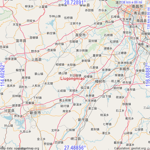
Liugongmiao GPS coordinates[2]
28° 6' 37.908" North, 115° 18' 20.664" East
| Map corner | latitude | longitude |
|---|---|---|
| Upper-left | 28.72891°, | 114.60262° |
| Center: | 28.11053°, | 115.30574° |
| Lower-right: | 27.48856°, | 116.00887° |
| Map W x H: | 137.9×137.9 km | = 85.7×85.7mi |
| max Lat: | 53.31946° ⇑73.2% North |
| Liugongmiao: | 28.11053° |
| min Lat: | ⇓26.8% South 18.22056° |
| min Long | Liugongmiao | max Long |
| 75.07348° | 115.30574° | 134.28917° |
| W 55.9%⇐ | ⇒44.1% E |
Elevation
Elevation of Liugongmiao is 49 m = 161 ft, and this is 435.8 m = 1430 ft below average elevation for this country.
| Max E: |
5622 m = 18445 ft | 70.8% |
| Avg. | 484.8 m = 1591 ft | |
| Liugongmiao | 49 m = 161 ft | |
Min E: |
-3 m = -10 ft | 29.2% |
See also: China elevation on elevation.city.
Geographical zone
Liugongmiao is located in North temperate zone (between Tropic of Cancer and the Arctic Circle). Distance of this Northern Tropic circle is 519.7 km =322.9 mi to South.| Distance of | km | miles | from Liugongmiao |
|---|---|---|---|
| North Pole | 6881.5 | 4276 | to North |
| Arctic Circle | 4275.6 | 2656.7 | to North |
| Tropic Cancer | 519.7 | 322.9 | to South |
| Equator | 3125.6 | 1942.2 | to South |


Nearby cities:
15 places around Liugongmiao: (largest is in red/bold)
• Bajing
18.9 km =11.7 mi,  66°
66°
• Changfu
21.2 km =13.2 mi,  179°
179°
• Huibu
21.1 km =13.1 mi,  345°
345°
• Jianshan
11.5 km =7.1 mi,  281°
281°
• Jinglou
11.9 km =7.4 mi,  95°
95°
• Taiyang
10.3 km =6.4 mi,  339°
339°
• Tiannan
19.5 km =12.1 mi,  268°
268°
• Xiangcheng
17.2 km =10.7 mi,  304°
304°
• Xinjie
16.9 km =10.5 mi,  36°
36°
• Xinjiezhen
16.9 km =10.5 mi, 36°
• Yanghuxiang
20.8 km =12.9 mi,  117°
117°
• Yicheng
19 km =11.8 mi,  222°
222°
• Zhangjiashan
17.3 km =10.7 mi, 99°
• Zhanxi
10.3 km =6.4 mi,  227°
227°
• Zhoushang
15.5 km =9.6 mi,  139°
139°
Sources, notices
• [Note1] Compared only with cities in China existing in our database
• [Src1] Map data: © OpenStreetMap contributors (CC-BY-SA)
• [Src2] Other city data from geonames.org with taken over terms of usage.
• [Src3] Geographical zone / Annual Mean Temperature by Robert A. Rohde @ Wikipedia
