Lianhe geodata
Lianhe (Guangdong) is a seat of a fourth-order administrative division; located in China in Asia/Shanghai (GMT+8) time zone. In our database, there are 1268 cities with bigger population. Compared to other cities in China, 93.4% of cities are located further ↑North; 54.9% of cities are located further →East and 56.9% of cities have higher elevation than Lianhe. Note1


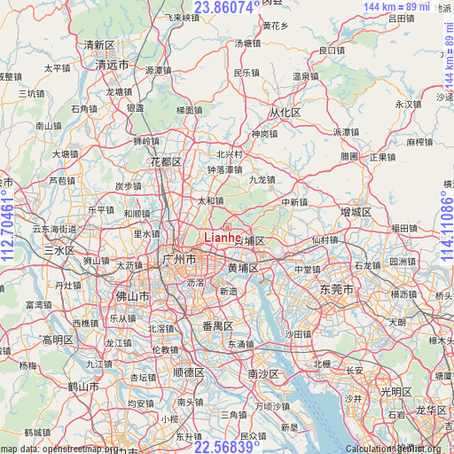
Lianhe GPS coordinates[2]
23° 12' 58.068" North, 113° 24' 27.828" East
| Map corner | latitude | longitude |
|---|---|---|
| Upper-left | 23.86074°, | 112.70461° |
| Center: | 23.21613°, | 113.40773° |
| Lower-right: | 22.56839°, | 114.11086° |
| Map W x H: | 143.7×143.7 km | = 89.3×89.3mi |
| max Lat: | 53.31946° ⇑93.4% North |
| Lianhe: | 23.21613° |
| min Lat: | ⇓6.6% South 18.22056° |
| min Long | Lianhe | max Long |
| 75.07348° | 113.40773° | 134.28917° |
| W 45.1%⇐ | ⇒54.9% E |
Elevation
Elevation of Lianhe is 118 m = 387 ft, and this is 366.8 m = 1203 ft below average elevation for this country.
| Max E: |
5622 m = 18445 ft | 56.9% |
| Avg. | 484.8 m = 1591 ft | |
| Lianhe | 118 m = 387 ft | |
Min E: |
-3 m = -10 ft | 43.1% |
See also: China elevation on elevation.city.
Geographical zone
Lianhe is located in North Torrid zone (between Equator and Tropic of Cancer). Distance of this Northern Tropic circle is 24.5 km =15.2 mi to North.| Distance of | km | miles | from Lianhe |
|---|---|---|---|
| North Pole | 7425.7 | 4614.1 | to North |
| Arctic Circle | 4819.8 | 2994.9 | to North |
| Tropic Cancer | 24.5 | 15.2 | to North |
| Equator | 2581.4 | 1604 | to South |


Nearby cities:
15 places around Lianhe: (largest is in red/bold)
• Changxing
7.5 km =4.7 mi,  236°
236°
• Changzhou
15 km =9.3 mi,  174°
174°
• Dasha
12.3 km =7.6 mi,  163°
163°
• Hongshan
14 km =8.7 mi,  154°
154°
• Huangcun
9.7 km =6 mi,  179°
179°
• Huangshi
14.8 km =9.2 mi,  267°
267°
• Jiahe
14.2 km =8.8 mi,  275°
275°
• Longdong
4 km =2.5 mi, 244°
• Luogang
10.4 km =6.5 mi,  114°
114°
• Taihe
10.3 km =6.4 mi,  324°
324°
• Tonghe
9.4 km =5.8 mi,  260°
260°
• Wushan
8.9 km =5.5 mi,  224°
224°
• Xintang
6 km =3.7 mi, 180°
• Yongping
11.1 km =6.9 mi, 279°
• Yuzhu
12.8 km =8 mi, 170°
Sources, notices
• [Note1] Compared only with cities in China existing in our database
• [Src1] Map data: © OpenStreetMap contributors (CC-BY-SA)
• [Src2] Other city data from geonames.org with taken over terms of usage.
• [Src3] Geographical zone / Annual Mean Temperature by Robert A. Rohde @ Wikipedia
