Shuangshipu geodata
Shuangshipu (Shaanxi) is a seat of a third-order administrative division; located in China in Asia/Shanghai (GMT+8) time zone. In our database, there are 1268 cities with bigger population. Compared to other cities in China, 69.7% of cities are located further ↓South; 85.1% of cities are located further →East and 84.7% of cities have lower elevation than Shuangshipu. Note1


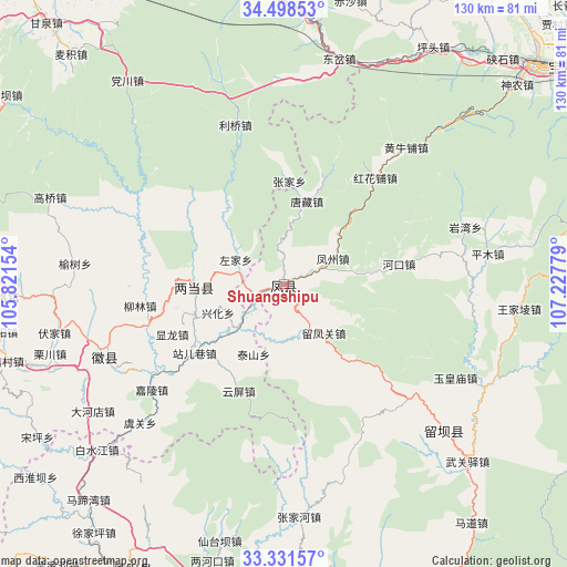
Shuangshipu GPS coordinates[2]
33° 55' 1.38" North, 106° 31' 28.776" East
| Map corner | latitude | longitude |
|---|---|---|
| Upper-left | 34.49853°, | 105.82154° |
| Center: | 33.91705°, | 106.52466° |
| Lower-right: | 33.33157°, | 107.22779° |
| Map W x H: | 129.8×129.8 km | = 80.7×80.7mi |
| max Lat: | 53.31946° ⇑30.3% North |
| Shuangshipu: | 33.91705° |
| min Lat: | ⇓69.7% South 18.22056° |
| min Long | Shuangshipu | max Long |
| 75.07348° | 106.52466° | 134.28917° |
| W 14.9%⇐ | ⇒85.1% E |
Elevation
Elevation of Shuangshipu is 962 m = 3156 ft, and this is 477.2 m = 1566 ft above average elevation for this country.
| Max E: |
5622 m = 18445 ft | 15.3% |
| Shuangshipu | 962 m 3156 ft | |
| Avg. | 484.8 m = 1591 ft | |
Min E: |
-3 m = -10 ft | 84.7% |
See also: China elevation on elevation.city.
Geographical zone
Shuangshipu is located in North temperate zone (between Tropic of Cancer and the Arctic Circle). Distance of this Northern Tropic circle is 1165.3 km =724.1 mi to South.| Distance of | km | miles | from Shuangshipu |
|---|---|---|---|
| North Pole | 6235.8 | 3874.7 | to North |
| Arctic Circle | 3630 | 2255.6 | to North |
| Tropic Cancer | 1165.3 | 724.1 | to South |
| Equator | 3771.2 | 2343.3 | to South |


Nearby cities:
15 places around Shuangshipu: (largest is in red/bold)
• Fengzhou
13.5 km =8.4 mi,  60°
60°
• Jindong
20 km =12.4 mi,  266°
266°
• Liangdang Chengguanzhen
20.5 km =12.7 mi, 267°
• Nanxing
21.3 km =13.2 mi,  140°
140°
• Sancha
16 km =9.9 mi,  121°
121°
• Taishan
17.2 km =10.7 mi,  201°
201°
• Tangzang
20 km =12.4 mi,  15°
15°
• Wenjiangsi
11.7 km =7.3 mi,  173°
173°
• Xinghua
16.3 km =10.1 mi,  247°
247°
• Xipo
11.6 km =7.2 mi,  228°
228°
• Yangdian
9.2 km =5.7 mi,  281°
281°
• Yuchi
25.1 km =15.6 mi, 248°
• Yunping
26.4 km =16.4 mi, 202°
• Zhan’erxiang
25.7 km =16 mi, 233°
• Zuojia
12.4 km =7.7 mi,  297°
297°
Sources, notices
• [Note1] Compared only with cities in China existing in our database
• [Src1] Map data: © OpenStreetMap contributors (CC-BY-SA)
• [Src2] Other city data from geonames.org with taken over terms of usage.
• [Src3] Geographical zone / Annual Mean Temperature by Robert A. Rohde @ Wikipedia
