Shimen geodata
Shimen (Anhui) is a seat of a fourth-order administrative division; located in China in Asia/Shanghai (GMT+8) time zone. In our database, there are 1268 cities with bigger population. Compared to other cities in China, 58.2% of cities are located further ↑North; 72.8% of cities are located further ←West and 60.5% of cities have lower elevation than Shimen. Note1


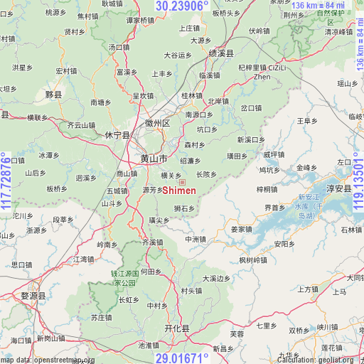
Shimen GPS coordinates[2]
29° 37' 47.064" North, 118° 25' 54.768" East
| Map corner | latitude | longitude |
|---|---|---|
| Upper-left | 30.23906°, | 117.72876° |
| Center: | 29.62974°, | 118.43188° |
| Lower-right: | 29.01671°, | 119.13501° |
| Map W x H: | 135.9×135.9 km | = 84.4×84.4mi |
| max Lat: | 53.31946° ⇑58.2% North |
| Shimen: | 29.62974° |
| min Lat: | ⇓41.8% South 18.22056° |
| min Long | Shimen | max Long |
| 75.07348° | 118.43188° | 134.28917° |
| W 72.8%⇐ | ⇒27.2% E |
Elevation
Elevation of Shimen is 266 m = 873 ft, and this is 218.8 m = 718 ft below average elevation for this country.
| Max E: |
5622 m = 18445 ft | 39.5% |
| Avg. | 484.8 m = 1591 ft | |
| Shimen | 266 m = 873 ft | |
Min E: |
-3 m = -10 ft | 60.5% |
See also: China elevation on elevation.city.
Geographical zone
Shimen is located in North temperate zone (between Tropic of Cancer and the Arctic Circle). Distance of this Northern Tropic circle is 688.6 km =427.9 mi to South.| Distance of | km | miles | from Shimen |
|---|---|---|---|
| North Pole | 6712.5 | 4171 | to North |
| Arctic Circle | 4106.7 | 2551.8 | to North |
| Tropic Cancer | 688.6 | 427.9 | to South |
| Equator | 3294.5 | 2047.1 | to South |


Nearby cities:
15 places around Shimen: (largest is in red/bold)
• Changgai
9.5 km =5.9 mi,  70°
70°
• Donglinxi
14.5 km =9 mi,  290°
290°
• Guocun
21 km =13 mi,  112°
112°
• Huangshan
14.7 km =9.1 mi,  308°
308°
• Liyang
16.4 km =10.2 mi,  300°
300°
• Sencun
15 km =9.3 mi,  17°
17°
• Shaolian
8.8 km =5.5 mi, 19°
• Tunguang
16.8 km =10.4 mi,  334°
334°
• Wangcun
14.5 km =9 mi,  347°
347°
• Xintan
18.8 km =11.7 mi, 309°
• Xiongcun
20.8 km =12.9 mi,  1°
1°
• Yanghu
14.8 km =9.2 mi, 303°
• Yiqi
20 km =12.4 mi, 302°
• Yujia
19 km =11.8 mi,  167°
167°
• Zhengwan
6.3 km =3.9 mi,  279°
279°
Sources, notices
• [Note1] Compared only with cities in China existing in our database
• [Src1] Map data: © OpenStreetMap contributors (CC-BY-SA)
• [Src2] Other city data from geonames.org with taken over terms of usage.
• [Src3] Geographical zone / Annual Mean Temperature by Robert A. Rohde @ Wikipedia
