Shibi geodata
Shibi (Hainan) is a seat of a fourth-order administrative division; located in China in Asia/Shanghai (GMT+8) time zone. In our database, there are 1268 cities with bigger population. Compared to other cities in China, 99.5% of cities are located further ↑North; 70% of cities are located further →East and 80.8% of cities have higher elevation than Shibi. Note1


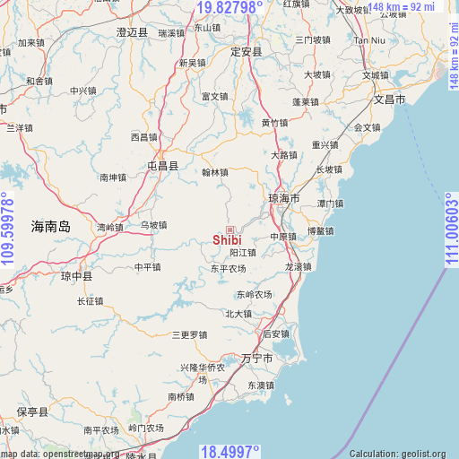
Shibi GPS coordinates[2]
19° 9' 54.648" North, 110° 18' 10.44" East
| Map corner | latitude | longitude |
|---|---|---|
| Upper-left | 19.82798°, | 109.59978° |
| Center: | 19.16518°, | 110.3029° |
| Lower-right: | 18.4997°, | 111.00603° |
| Map W x H: | 147.7×147.7 km | = 91.8×91.8mi |
| max Lat: | 53.31946° ⇑99.5% North |
| Shibi: | 19.16518° |
| min Lat: | ⇓0.5% South 18.22056° |
| min Long | Shibi | max Long |
| 75.07348° | 110.3029° | 134.28917° |
| W 30%⇐ | ⇒70% E |
Elevation
Elevation of Shibi is 25 m = 82 ft, and this is 459.8 m = 1509 ft below average elevation for this country.
| Max E: |
5622 m = 18445 ft | 80.8% |
| Avg. | 484.8 m = 1591 ft | |
| Shibi | 25 m = 82 ft | |
Min E: |
-3 m = -10 ft | 19.2% |
See also: China elevation on elevation.city.
Geographical zone
Shibi is located in North Torrid zone (between Equator and Tropic of Cancer). Distance of this Northern Tropic circle is 475 km =295.2 mi to North.| Distance of | km | miles | from Shibi |
|---|---|---|---|
| North Pole | 7876.1 | 4894 | to North |
| Arctic Circle | 5270.2 | 3274.7 | to North |
| Tropic Cancer | 475 | 295.2 | to North |
| Equator | 2131 | 1324.1 | to South |


Nearby cities:
15 places around Shibi: (largest is in red/bold)
• Beida
27 km =16.8 mi,  173°
173°
• Hanlin
19.3 km =12 mi,  345°
345°
• Huishan
11.5 km =7.1 mi,  202°
202°
• Lingkou
19.9 km =12.4 mi,  0°
0°
• Longgun
26.5 km =16.5 mi,  118°
118°
• Longhe
26 km =16.2 mi,  338°
338°
• Longjiang
2.6 km =1.6 mi,  137°
137°
• Nanlü
25.7 km =16 mi,  291°
291°
• Poxin
27.6 km =17.1 mi,  303°
303°
• Qionghai
19 km =11.8 mi,  63°
63°
• Tayang
25.4 km =15.8 mi, 56°
• Wanquan
13.8 km =8.6 mi,  50°
50°
• Wupo
24.8 km =15.4 mi,  274°
274°
• Yangjiang
8.3 km =5.2 mi,  149°
149°
• Zhongyuan
17.4 km =10.8 mi,  96°
96°
Sources, notices
• [Note1] Compared only with cities in China existing in our database
• [Src1] Map data: © OpenStreetMap contributors (CC-BY-SA)
• [Src2] Other city data from geonames.org with taken over terms of usage.
• [Src3] Geographical zone / Annual Mean Temperature by Robert A. Rohde @ Wikipedia
