Shibantan geodata
Shibantan (Hunan) is a seat of a fourth-order administrative division; located in China in Asia/Shanghai (GMT+8) time zone. In our database, there are 1268 cities with bigger population. Compared to other cities in China, 63.7% of cities are located further ↑North; 64.3% of cities are located further →East and 69.7% of cities have higher elevation than Shibantan. Note1


Shibantan GPS coordinates[2]
29° 9' 24.12" North, 111° 38' 2.688" East
| Map corner | latitude | longitude |
|---|---|---|
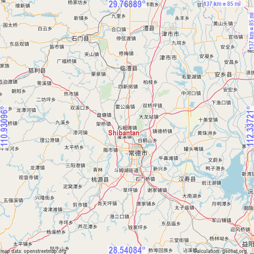
| Upper-left | 29.76889°, | 110.93096° |
| Center: | 29.1567°, | 111.63408° |
| Lower-right: | 28.54084°, | 112.33721° |
| Map W x H: | 136.5×136.5 km | = 84.8×84.8mi |
| max Lat: | 53.31946° ⇑63.7% North |
| Shibantan: | 29.1567° |
| min Lat: | ⇓36.3% South 18.22056° |
| min Long | Shibantan | max Long |
| 75.07348° | 111.63408° | 134.28917° |
| W 35.7%⇐ | ⇒64.3% E |
Elevation
Elevation of Shibantan is 53 m = 174 ft, and this is 431.8 m = 1417 ft below average elevation for this country.
| Max E: |
5622 m = 18445 ft | 69.7% |
| Avg. | 484.8 m = 1591 ft | |
| Shibantan | 53 m = 174 ft | |
Min E: |
-3 m = -10 ft | 30.3% |
See also: China elevation on elevation.city.
Geographical zone
Shibantan is located in North temperate zone (between Tropic of Cancer and the Arctic Circle). Distance of this Northern Tropic circle is 636 km =395.2 mi to South.| Distance of | km | miles | from Shibantan |
|---|---|---|---|
| North Pole | 6765.1 | 4203.6 | to North |
| Arctic Circle | 4159.3 | 2584.5 | to North |
| Tropic Cancer | 636 | 395.2 | to South |
| Equator | 3241.9 | 2014.4 | to South |


Nearby cities:
15 places around Shibantan: (largest is in red/bold)
• Caijiagang
3.9 km =2.4 mi,  336°
336°
• Changde
13 km =8.1 mi,  160°
160°
• Changlinggang
10.2 km =6.3 mi,  33°
33°
• Dalongzhan
12.7 km =7.9 mi,  65°
65°
• Dingcheng
15.9 km =9.9 mi, 163°
• Guanxi
5.2 km =3.2 mi,  199°
199°
• Hefu
13.6 km =8.5 mi, 195°
• Hucheng
12.7 km =7.9 mi,  169°
169°
• Hucheng
13.8 km =8.6 mi, 158°
• Jiaqiao
13.3 km =8.3 mi,  274°
274°
• Leigongmiao
11.2 km =7 mi,  351°
351°
• Nanpinggang
11.3 km =7 mi,  153°
153°
• Pantang
14 km =8.7 mi,  297°
297°
• Taifu
15.5 km =9.6 mi, 342°
• Zoushi
15.6 km =9.7 mi,  216°
216°
Sources, notices
• [Note1] Compared only with cities in China existing in our database
• [Src1] Map data: © OpenStreetMap contributors (CC-BY-SA)
• [Src2] Other city data from geonames.org with taken over terms of usage.
• [Src3] Geographical zone / Annual Mean Temperature by Robert A. Rohde @ Wikipedia
