Changde geodata
Changde (Hunan) is a seat of a third-order administrative division; located in China in Asia/Shanghai (GMT+8) time zone. With population of 517,780 people, there are 124 cities with bigger population in this country. Compared to other cities in China, 64.9% of cities are located further ↑North; 64.1% of cities are located further →East and 75.7% of cities have higher elevation than Changde. Note1


Changde GPS coordinates[2]
29° 2' 46.968" North, 111° 40' 41.88" East
| Map corner | latitude | longitude |
|---|---|---|
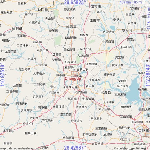
| Upper-left | 29.65923°, | 110.97518° |
| Center: | 29.04638°, | 111.6783° |
| Lower-right: | 28.42987°, | 112.38143° |
| Map W x H: | 136.7×136.7 km | = 84.9×84.9mi |
| max Lat: | 53.31946° ⇑64.9% North |
| Changde: | 29.04638° |
| min Lat: | ⇓35.1% South 18.22056° |
| min Long | Changde | max Long |
| 75.07348° | 111.6783° | 134.28917° |
| W 35.9%⇐ | ⇒64.1% E |
Elevation
Elevation of Changde is 35 m = 115 ft, and this is 449.8 m = 1476 ft below average elevation for this country.
| Max E: |
5622 m = 18445 ft | 75.7% |
| Avg. | 484.8 m = 1591 ft | |
| Changde | 35 m = 115 ft | |
Min E: |
-3 m = -10 ft | 24.3% |
See also: Changde elevation on elevation.city.
Geographical zone
Changde is located in North temperate zone (between Tropic of Cancer and the Arctic Circle). Distance of this Northern Tropic circle is 623.7 km =387.5 mi to South.| Distance of | km | miles | from Changde |
|---|---|---|---|
| North Pole | 6777.4 | 4211.3 | to North |
| Arctic Circle | 4171.5 | 2592 | to North |
| Tropic Cancer | 623.7 | 387.5 | to South |
| Equator | 3229.7 | 2006.8 | to South |


Nearby cities:
15 places around Changde: (largest is in red/bold)
• Danzhou
5.9 km =3.7 mi,  225°
225°
• Deshan
13.5 km =8.4 mi,  165°
165°
• Dingcheng
3 km =1.9 mi,  177°
177°
• Dongjiang
6.8 km =4.2 mi,  101°
101°
• Dongjiao
4.2 km =2.6 mi,  132°
132°
• Doumuhu
11.9 km =7.4 mi,  204°
204°
• Guanxi
9.5 km =5.9 mi,  320°
320°
• Hefu
7.9 km =4.9 mi,  263°
263°
• Hucheng
0.9 km =0.6 mi, 125°
• Hucheng
1.9 km =1.2 mi,  265°
265°
• Ludishan
7.2 km =4.5 mi, 129°
• Mutangyuan
13 km =8.1 mi,  254°
254°
• Nanpinggang
2.2 km =1.4 mi,  17°
17°
• Shibantan
13 km =8.1 mi,  340°
340°
• Zoushi
13.6 km =8.5 mi, 268°
Sources, notices
• [Note1] Compared only with cities in China existing in our database
• [Src1] Map data: © OpenStreetMap contributors (CC-BY-SA)
• [Src2] Other city data from geonames.org with taken over terms of usage.
• [Src3] Geographical zone / Annual Mean Temperature by Robert A. Rohde @ Wikipedia
