Yuxin geodata
Yuxin (Zhejiang) is a seat of a fourth-order administrative division; located in China in Asia/Shanghai (GMT+8) time zone. In our database, there are 1268 cities with bigger population. Compared to other cities in China, 51.8% of cities are located further ↓South; 86.7% of cities are located further ←West and 91.2% of cities have higher elevation than Yuxin. Note1


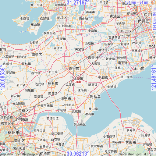
Yuxin GPS coordinates[2]
30° 40' 7.644" North, 120° 47' 18.528" East
| Map corner | latitude | longitude |
|---|---|---|
| Upper-left | 31.27167°, | 120.08536° |
| Center: | 30.66879°, | 120.78848° |
| Lower-right: | 30.06213°, | 121.49161° |
| Map W x H: | 134.5×134.5 km | = 83.6×83.6mi |
| max Lat: | 53.31946° ⇑48.2% North |
| Yuxin: | 30.66879° |
| min Lat: | ⇓51.8% South 18.22056° |
| min Long | Yuxin | max Long |
| 75.07348° | 120.78848° | 134.28917° |
| W 86.7%⇐ | ⇒13.3% E |
Elevation
Elevation of Yuxin is 9 m = 30 ft, and this is 475.8 m = 1561 ft below average elevation for this country.
| Max E: |
5622 m = 18445 ft | 91.2% |
| Avg. | 484.8 m = 1591 ft | |
| Yuxin | 9 m = 30 ft | |
Min E: |
-3 m = -10 ft | 8.8% |
See also: China elevation on elevation.city.
Geographical zone
Yuxin is located in North temperate zone (between Tropic of Cancer and the Arctic Circle). Distance of this Northern Tropic circle is 804.1 km =499.6 mi to South.| Distance of | km | miles | from Yuxin |
|---|---|---|---|
| North Pole | 6597 | 4099.2 | to North |
| Arctic Circle | 3991.1 | 2480 | to North |
| Tropic Cancer | 804.1 | 499.6 | to South |
| Equator | 3410 | 2118.9 | to South |


Nearby cities:
15 places around Yuxin: (largest is in red/bold)
• Baibu
14.1 km =8.8 mi,  184°
184°
• Chengnan
9.5 km =5.9 mi,  323°
323°
• Daqiao
10.9 km =6.8 mi,  36°
36°
• Dongzha
10.3 km =6.4 mi,  358°
358°
• Fengqiao
6.4 km =4 mi,  97°
97°
• Hengjingqiao
12.5 km =7.8 mi,  277°
277°
• Jiabei
14.3 km =8.9 mi,  329°
329°
• Jiaxing
10 km =6.2 mi,  338°
338°
• Jiefang
12.4 km =7.7 mi,  348°
348°
• Puyuan
15.3 km =9.5 mi,  274°
274°
• Shendang
10.6 km =6.6 mi,  162°
162°
• Tanghui
14.1 km =8.8 mi, 353°
• Wangdian
8.6 km =5.3 mi,  234°
234°
• Xinfeng
13.2 km =8.2 mi,  70°
70°
• Xinhuang
13.2 km =8.2 mi,  113°
113°
Sources, notices
• [Note1] Compared only with cities in China existing in our database
• [Src1] Map data: © OpenStreetMap contributors (CC-BY-SA)
• [Src2] Other city data from geonames.org with taken over terms of usage.
• [Src3] Geographical zone / Annual Mean Temperature by Robert A. Rohde @ Wikipedia
