Shanwei geodata
Shanwei (Guangdong) is a seat of a second-order administrative division; located in China in Asia/Shanghai (GMT+8) time zone. With population of 165,699 people, there are 268 cities with bigger population in this country. Compared to other cities in China, 95.4% of cities are located further ↑North; 56.1% of cities are located further ←West and 91.2% of cities have higher elevation than Shanwei. Note1


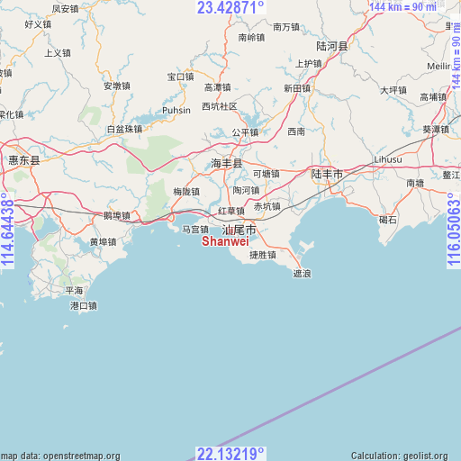
Shanwei GPS coordinates[2]
22° 46' 55.164" North, 115° 20' 51" East
| Map corner | latitude | longitude |
|---|---|---|
| Upper-left | 23.42871°, | 114.64438° |
| Center: | 22.78199°, | 115.3475° |
| Lower-right: | 22.13219°, | 116.05063° |
| Map W x H: | 144.2×144.2 km | = 89.6×89.6mi |
| max Lat: | 53.31946° ⇑95.4% North |
| Shanwei: | 22.78199° |
| min Lat: | ⇓4.6% South 18.22056° |
| min Long | Shanwei | max Long |
| 75.07348° | 115.3475° | 134.28917° |
| W 56.1%⇐ | ⇒43.9% E |
Elevation
Elevation of Shanwei is 9 m = 30 ft, and this is 475.8 m = 1561 ft below average elevation for this country.
| Max E: |
5622 m = 18445 ft | 91.2% |
| Avg. | 484.8 m = 1591 ft | |
| Shanwei | 9 m = 30 ft | |
Min E: |
-3 m = -10 ft | 8.8% |
See also: Shanwei elevation on elevation.city.
Geographical zone
Shanwei is located in North Torrid zone (between Equator and Tropic of Cancer). Distance of this Northern Tropic circle is 72.8 km =45.2 mi to North.| Distance of | km | miles | from Shanwei |
|---|---|---|---|
| North Pole | 7473.9 | 4644.1 | to North |
| Arctic Circle | 4868.1 | 3024.9 | to North |
| Tropic Cancer | 72.8 | 45.2 | to North |
| Equator | 2533.1 | 1574 | to South |


Nearby cities:
15 places around Shanwei: (largest is in red/bold)
• Chikeng
13.9 km =8.6 mi,  55°
55°
• Dongyong
8.2 km =5.1 mi,  79°
79°
• Dongzhou
19.9 km =12.4 mi,  112°
112°
• Fengshan
3.1 km =1.9 mi,  173°
173°
• Haicheng
21.6 km =13.4 mi,  355°
355°
• Hongcao
6 km =3.7 mi,  33°
33°
• Houmen
20.1 km =12.5 mi,  280°
280°
• Jiesheng
12.5 km =7.8 mi,  124°
124°
• Ketang
20.8 km =12.9 mi, 34°
• Lian’an
15.5 km =9.6 mi,  339°
339°
• Magong
11.2 km =7 mi,  274°
274°
• Meilong
18.5 km =11.5 mi,  311°
311°
• Taohe
14.2 km =8.8 mi, 27°
• Tiangan
17.6 km =10.9 mi, 110°
• Tianqian
17 km =10.6 mi, 110°
Sources, notices
• [Note1] Compared only with cities in China existing in our database
• [Src1] Map data: © OpenStreetMap contributors (CC-BY-SA)
• [Src2] Other city data from geonames.org with taken over terms of usage.
• [Src3] Geographical zone / Annual Mean Temperature by Robert A. Rohde @ Wikipedia
