Dongzhou geodata
Dongzhou (Guangdong) is a seat of a fourth-order administrative division; located in China in Asia/Shanghai (GMT+8) time zone. In our database, there are 1268 cities with bigger population. Compared to other cities in China, 95.6% of cities are located further ↑North; 57.1% of cities are located further ←West and 88.7% of cities have higher elevation than Dongzhou. Note1


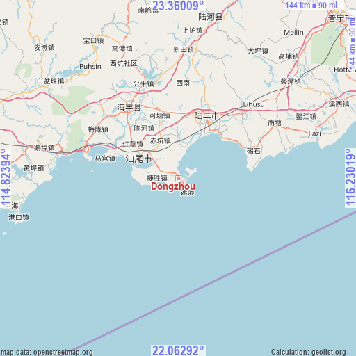
Dongzhou GPS coordinates[2]
22° 42' 46.944" North, 115° 31' 37.416" East
| Map corner | latitude | longitude |
|---|---|---|
| Upper-left | 23.36009°, | 114.82394° |
| Center: | 22.71304°, | 115.52706° |
| Lower-right: | 22.06292°, | 116.23019° |
| Map W x H: | 144.2×144.2 km | = 89.6×89.6mi |
| max Lat: | 53.31946° ⇑95.6% North |
| Dongzhou: | 22.71304° |
| min Lat: | ⇓4.4% South 18.22056° |
| min Long | Dongzhou | max Long |
| 75.07348° | 115.52706° | 134.28917° |
| W 57.1%⇐ | ⇒42.9% E |
Elevation
Elevation of Dongzhou is 11 m = 36 ft, and this is 473.8 m = 1554 ft below average elevation for this country.
| Max E: |
5622 m = 18445 ft | 88.7% |
| Avg. | 484.8 m = 1591 ft | |
| Dongzhou | 11 m = 36 ft | |
Min E: |
-3 m = -10 ft | 11.3% |
See also: China elevation on elevation.city.
Geographical zone
Dongzhou is located in North Torrid zone (between Equator and Tropic of Cancer). Distance of this Northern Tropic circle is 80.5 km =50 mi to North.| Distance of | km | miles | from Dongzhou |
|---|---|---|---|
| North Pole | 7481.6 | 4648.8 | to North |
| Arctic Circle | 4875.7 | 3029.6 | to North |
| Tropic Cancer | 80.5 | 50 | to North |
| Equator | 2525.5 | 1569.3 | to South |


Nearby cities:
15 places around Dongzhou: (largest is in red/bold)
• Chikeng
17.1 km =10.6 mi,  335°
335°
• Dahu
14.5 km =9 mi,  16°
16°
• Dongyong
13.8 km =8.6 mi,  311°
311°
• Fengshan
18.6 km =11.6 mi,  284°
284°
• Hongcao
19.8 km =12.3 mi, 309°
• Jiesheng
8.2 km =5.1 mi,  273°
273°
• Jinxiang
26.5 km =16.5 mi,  51°
51°
• Ketang
25.7 km =16 mi,  345°
345°
• Shangying
19.4 km =12.1 mi,  11°
11°
• Shanwei
19.9 km =12.4 mi,  292°
292°
• Tanxi
25 km =15.5 mi, 8°
• Taohe
23.5 km =14.6 mi,  329°
329°
• Tiangan
2.4 km =1.5 mi, 307°
• Tianqian
3 km =1.9 mi,  303°
303°
• Zhelang
6.1 km =3.8 mi,  137°
137°
Sources, notices
• [Note1] Compared only with cities in China existing in our database
• [Src1] Map data: © OpenStreetMap contributors (CC-BY-SA)
• [Src2] Other city data from geonames.org with taken over terms of usage.
• [Src3] Geographical zone / Annual Mean Temperature by Robert A. Rohde @ Wikipedia
