Ruishi geodata
Ruishi (Hunan) is a seat of a fourth-order administrative division; located in China in Asia/Shanghai (GMT+8) time zone. In our database, there are 1268 cities with bigger population. Compared to other cities in China, 60.6% of cities are located further ↑North; 70.1% of cities are located further →East and 64.8% of cities have lower elevation than Ruishi. Note1


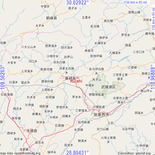
Ruishi GPS coordinates[2]
29° 25' 6.996" North, 110° 15' 56.7" East
| Map corner | latitude | longitude |
|---|---|---|
| Upper-left | 30.02922°, | 109.56263° |
| Center: | 29.41861°, | 110.26575° |
| Lower-right: | 28.80431°, | 110.96888° |
| Map W x H: | 136.2×136.2 km | = 84.6×84.6mi |
| max Lat: | 53.31946° ⇑60.6% North |
| Ruishi: | 29.41861° |
| min Lat: | ⇓39.4% South 18.22056° |
| min Long | Ruishi | max Long |
| 75.07348° | 110.26575° | 134.28917° |
| W 29.9%⇐ | ⇒70.1% E |
Elevation
Elevation of Ruishi is 321 m = 1053 ft, and this is 163.8 m = 537 ft below average elevation for this country.
| Max E: |
5622 m = 18445 ft | 35.2% |
| Avg. | 484.8 m = 1591 ft | |
| Ruishi | 321 m = 1053 ft | |
Min E: |
-3 m = -10 ft | 64.8% |
See also: China elevation on elevation.city.
Geographical zone
Ruishi is located in North temperate zone (between Tropic of Cancer and the Arctic Circle). Distance of this Northern Tropic circle is 665.1 km =413.3 mi to South.| Distance of | km | miles | from Ruishi |
|---|---|---|---|
| North Pole | 6736 | 4185.6 | to North |
| Arctic Circle | 4130.1 | 2566.3 | to North |
| Tropic Cancer | 665.1 | 413.3 | to South |
| Equator | 3271 | 2032.5 | to South |


Nearby cities:
15 places around Ruishi: (largest is in red/bold)
• Furongqiao
11.1 km =6.9 mi,  17°
17°
• Hongjiaguan
11.6 km =7.2 mi,  304°
304°
• Jiaoziya
15.5 km =9.6 mi,  159°
159°
• Kongkeshu
8 km =5 mi,  72°
72°
• Liyuan
10.9 km =6.8 mi,  256°
256°
• Louziqiu
16.9 km =10.5 mi,  35°
35°
• Luoshui
16.8 km =10.4 mi,  184°
184°
• Maidiping
12.1 km =7.5 mi,  47°
47°
• Qiaotou
8.1 km =5 mi,  167°
167°
• Souziqiu
16.8 km =10.4 mi,  34°
34°
• Suoziqiu
16.9 km =10.5 mi, 35°
• Tianzishan
16.6 km =10.3 mi,  93°
93°
• Zhangjiaqiao
15.5 km =9.6 mi,  309°
309°
• Zhonghuping
12.8 km =8 mi,  118°
118°
• Zhujita
6.8 km =4.2 mi,  323°
323°
Sources, notices
• [Note1] Compared only with cities in China existing in our database
• [Src1] Map data: © OpenStreetMap contributors (CC-BY-SA)
• [Src2] Other city data from geonames.org with taken over terms of usage.
• [Src3] Geographical zone / Annual Mean Temperature by Robert A. Rohde @ Wikipedia
