Rouyuan geodata
Rouyuan (Gansu) is a seat of a fourth-order administrative division; located in China in Asia/Shanghai (GMT+8) time zone. In our database, there are 1268 cities with bigger population. Compared to other cities in China, 78.2% of cities are located further ↓South; 80.6% of cities are located further →East and 89.1% of cities have lower elevation than Rouyuan. Note1


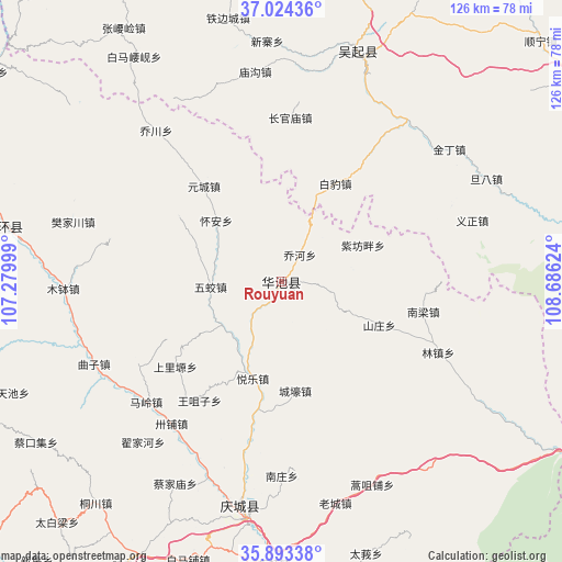
Rouyuan GPS coordinates[2]
36° 27' 39.348" North, 107° 58' 59.196" East
| Map corner | latitude | longitude |
|---|---|---|
| Upper-left | 37.02436°, | 107.27999° |
| Center: | 36.46093°, | 107.98311° |
| Lower-right: | 35.89338°, | 108.68624° |
| Map W x H: | 125.8×125.8 km | = 78.2×78.2mi |
| max Lat: | 53.31946° ⇑21.8% North |
| Rouyuan: | 36.46093° |
| min Lat: | ⇓78.2% South 18.22056° |
| min Long | Rouyuan | max Long |
| 75.07348° | 107.98311° | 134.28917° |
| W 19.4%⇐ | ⇒80.6% E |
Elevation
Elevation of Rouyuan is 1276 m = 4186 ft, and this is 791.2 m = 2596 ft above average elevation for this country.
| Max E: |
5622 m = 18445 ft | 10.9% |
| Rouyuan | 1276 m 4186 ft | |
| Avg. | 484.8 m = 1591 ft | |
Min E: |
-3 m = -10 ft | 89.1% |
See also: China elevation on elevation.city.
Geographical zone
Rouyuan is located in North temperate zone (between Tropic of Cancer and the Arctic Circle). Distance of this Northern Tropic circle is 1448.2 km =899.9 mi to South.| Distance of | km | miles | from Rouyuan |
|---|---|---|---|
| North Pole | 5953 | 3699 | to North |
| Arctic Circle | 3347.1 | 2079.8 | to North |
| Tropic Cancer | 1448.2 | 899.9 | to South |
| Equator | 4054.1 | 2519.1 | to South |


Nearby cities:
15 places around Rouyuan: (largest is in red/bold)
• Baima
27.4 km =17 mi,  302°
302°
• Bazhu
37.9 km =23.5 mi,  285°
285°
• Huai’an
20.1 km =12.5 mi,  312°
312°
• Liliangzi
17.2 km =10.7 mi,  238°
238°
• Maling
40.7 km =25.3 mi,  228°
228°
• Miaoxiang
7.5 km =4.7 mi,  2°
2°
• Nanzhuang
43.6 km =27.1 mi,  180°
180°
• Shangliyuan
30.6 km =19 mi, 231°
• Wangzuizi
32.2 km =20 mi,  214°
214°
• Wentai
12.7 km =7.9 mi, 212°
• Wujiao
15.9 km =9.9 mi,  265°
265°
• Xuanma
43.5 km =27 mi,  190°
190°
• Xujiahe
37.3 km =23.2 mi,  249°
249°
• Yuancheng
27.4 km =17 mi,  320°
320°
• Yuele
22.7 km =14.1 mi,  196°
196°
Sources, notices
• [Note1] Compared only with cities in China existing in our database
• [Src1] Map data: © OpenStreetMap contributors (CC-BY-SA)
• [Src2] Other city data from geonames.org with taken over terms of usage.
• [Src3] Geographical zone / Annual Mean Temperature by Robert A. Rohde @ Wikipedia
