Qiuchuan geodata
Qiuchuan (Zhejiang) is a seat of a fourth-order administrative division; located in China in Asia/Shanghai (GMT+8) time zone. In our database, there are 1268 cities with bigger population. Compared to other cities in China, 66.6% of cities are located further ↑North; 72.1% of cities are located further ←West and 51.7% of cities have lower elevation than Qiuchuan. Note1


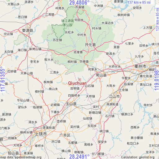
Qiuchuan GPS coordinates[2]
28° 52' 0.012" North, 118° 19' 0.012" East
| Map corner | latitude | longitude |
|---|---|---|
| Upper-left | 29.4806°, | 117.61355° |
| Center: | 28.86667°, | 118.31667° |
| Lower-right: | 28.2491°, | 119.0198° |
| Map W x H: | 136.9×136.9 km | = 85.1×85.1mi |
| max Lat: | 53.31946° ⇑66.6% North |
| Qiuchuan: | 28.86667° |
| min Lat: | ⇓33.4% South 18.22056° |
| min Long | Qiuchuan | max Long |
| 75.07348° | 118.31667° | 134.28917° |
| W 72.1%⇐ | ⇒27.9% E |
Elevation
Elevation of Qiuchuan is 179 m = 587 ft, and this is 305.8 m = 1003 ft below average elevation for this country.
| Max E: |
5622 m = 18445 ft | 48.3% |
| Avg. | 484.8 m = 1591 ft | |
| Qiuchuan | 179 m = 587 ft | |
Min E: |
-3 m = -10 ft | 51.7% |
See also: China elevation on elevation.city.
Geographical zone
Qiuchuan is located in North temperate zone (between Tropic of Cancer and the Arctic Circle). Distance of this Northern Tropic circle is 603.8 km =375.2 mi to South.| Distance of | km | miles | from Qiuchuan |
|---|---|---|---|
| North Pole | 6797.4 | 4223.7 | to North |
| Arctic Circle | 4191.5 | 2604.5 | to North |
| Tropic Cancer | 603.8 | 375.2 | to South |
| Equator | 3209.7 | 1994.4 | to South |


Nearby cities:
15 places around Qiuchuan: (largest is in red/bold)
• Baishijie
9.8 km =6.1 mi,  119°
119°
• Baiyun
12.1 km =7.5 mi,  175°
175°
• Daqiao
16.3 km =10.1 mi,  147°
147°
• Fengjia
19.1 km =11.9 mi,  29°
29°
• Hengjie
24.7 km =15.3 mi,  223°
223°
• Huabu
17.1 km =10.6 mi,  10°
10°
• Liudu
24.5 km =15.2 mi, 182°
• Lujiawu
17 km =10.6 mi,  337°
337°
• Nanshan
23.6 km =14.7 mi,  252°
252°
• Sanqing
22.7 km =14.1 mi,  286°
286°
• Siguqiao
14.4 km =8.9 mi,  201°
201°
• Tanshi
24.1 km =15 mi,  134°
134°
• Xingkou
24 km =14.9 mi,  356°
356°
• Yanrui
17.1 km =10.6 mi,  173°
173°
• Zihu
16.4 km =10.2 mi, 285°
Sources, notices
• [Note1] Compared only with cities in China existing in our database
• [Src1] Map data: © OpenStreetMap contributors (CC-BY-SA)
• [Src2] Other city data from geonames.org with taken over terms of usage.
• [Src3] Geographical zone / Annual Mean Temperature by Robert A. Rohde @ Wikipedia
