Baishijie geodata
Baishijie (Zhejiang) is a seat of a fourth-order administrative division; located in China in Asia/Shanghai (GMT+8) time zone. In our database, there are 1268 cities with bigger population. Compared to other cities in China, 67% of cities are located further ↑North; 72.6% of cities are located further ←West and 51.2% of cities have higher elevation than Baishijie. Note1


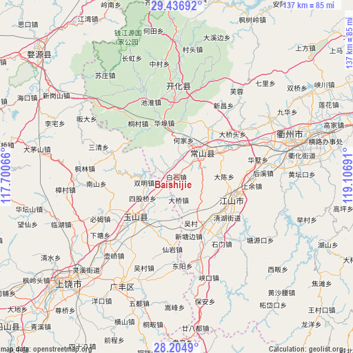
Baishijie GPS coordinates[2]
28° 49' 21.828" North, 118° 24' 13.608" East
| Map corner | latitude | longitude |
|---|---|---|
| Upper-left | 29.43692°, | 117.70066° |
| Center: | 28.82273°, | 118.40378° |
| Lower-right: | 28.2049°, | 119.10691° |
| Map W x H: | 137×137 km | = 85.1×85.1mi |
| max Lat: | 53.31946° ⇑67% North |
| Baishijie: | 28.82273° |
| min Lat: | ⇓33% South 18.22056° |
| min Long | Baishijie | max Long |
| 75.07348° | 118.40378° | 134.28917° |
| W 72.6%⇐ | ⇒27.4% E |
Elevation
Elevation of Baishijie is 155 m = 509 ft, and this is 329.8 m = 1082 ft below average elevation for this country.
| Max E: |
5622 m = 18445 ft | 51.2% |
| Avg. | 484.8 m = 1591 ft | |
| Baishijie | 155 m = 509 ft | |
Min E: |
-3 m = -10 ft | 48.8% |
See also: China elevation on elevation.city.
Geographical zone
Baishijie is located in North temperate zone (between Tropic of Cancer and the Arctic Circle). Distance of this Northern Tropic circle is 598.9 km =372.1 mi to South.| Distance of | km | miles | from Baishijie |
|---|---|---|---|
| North Pole | 6802.3 | 4226.8 | to North |
| Arctic Circle | 4196.4 | 2607.5 | to North |
| Tropic Cancer | 598.9 | 372.1 | to South |
| Equator | 3204.8 | 1991.4 | to South |


Nearby cities:
15 places around Baishijie: (largest is in red/bold)
• Baiyun
10.5 km =6.5 mi,  226°
226°
• Daqiao
8.9 km =5.5 mi,  178°
178°
• Fengjia
21.5 km =13.4 mi,  2°
2°
• Hecun
20.9 km =13 mi,  144°
144°
• Huabu
22.4 km =13.9 mi,  346°
346°
• Liudu
21.9 km =13.6 mi,  206°
206°
• Qiuchuan
9.8 km =6.1 mi,  299°
299°
• Shangsongfan
22.4 km =13.9 mi,  32°
32°
• Siguqiao
16.2 km =10.1 mi,  238°
238°
• Tanshi
14.8 km =9.2 mi, 143°
• Wucun
18.8 km =11.7 mi,  164°
164°
• Xiazhen
19.6 km =12.2 mi, 180°
• Xintangbian
22.8 km =14.2 mi,  168°
168°
• Yanrui
13.7 km =8.5 mi, 208°
• Yutou
24.5 km =15.2 mi, 156°
Sources, notices
• [Note1] Compared only with cities in China existing in our database
• [Src1] Map data: © OpenStreetMap contributors (CC-BY-SA)
• [Src2] Other city data from geonames.org with taken over terms of usage.
• [Src3] Geographical zone / Annual Mean Temperature by Robert A. Rohde @ Wikipedia
