Hengjie geodata
Hengjie (Jiangxi) is a seat of a fourth-order administrative division; located in China in Asia/Shanghai (GMT+8) time zone. In our database, there are 1268 cities with bigger population. Compared to other cities in China, 67.9% of cities are located further ↑North; 71.2% of cities are located further ←West and 58.8% of cities have higher elevation than Hengjie. Note1


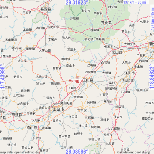
Hengjie GPS coordinates[2]
28° 42' 15.804" North, 118° 8' 35.16" East
| Map corner | latitude | longitude |
|---|---|---|
| Upper-left | 29.31928°, | 117.43998° |
| Center: | 28.70439°, | 118.1431° |
| Lower-right: | 28.08586°, | 118.84623° |
| Map W x H: | 137.1×137.1 km | = 85.2×85.2mi |
| max Lat: | 53.31946° ⇑67.9% North |
| Hengjie: | 28.70439° |
| min Lat: | ⇓32.1% South 18.22056° |
| min Long | Hengjie | max Long |
| 75.07348° | 118.1431° | 134.28917° |
| W 71.2%⇐ | ⇒28.8% E |
Elevation
Elevation of Hengjie is 106 m = 348 ft, and this is 378.8 m = 1243 ft below average elevation for this country.
| Max E: |
5622 m = 18445 ft | 58.8% |
| Avg. | 484.8 m = 1591 ft | |
| Hengjie | 106 m = 348 ft | |
Min E: |
-3 m = -10 ft | 41.2% |
See also: China elevation on elevation.city.
Geographical zone
Hengjie is located in North temperate zone (between Tropic of Cancer and the Arctic Circle). Distance of this Northern Tropic circle is 585.7 km =363.9 mi to South.| Distance of | km | miles | from Hengjie |
|---|---|---|---|
| North Pole | 6815.4 | 4234.9 | to North |
| Arctic Circle | 4209.5 | 2615.7 | to North |
| Tropic Cancer | 585.7 | 363.9 | to South |
| Equator | 3191.6 | 1983.2 | to South |


Nearby cities:
15 places around Hengjie: (largest is in red/bold)
• Baiyun
18.8 km =11.7 mi,  71°
71°
• Bimu
5.3 km =3.3 mi,  234°
234°
• Danan
19.9 km =12.4 mi,  150°
150°
• Huacun
19.7 km =12.2 mi,  131°
131°
• Huanggu
21 km =13 mi, 229°
• Hufeng
13.5 km =8.4 mi,  159°
159°
• Huqiao
17.4 km =10.8 mi,  175°
175°
• Linhu
20.6 km =12.8 mi,  256°
256°
• Liudu
17.1 km =10.6 mi,  112°
112°
• Nanshan
12.4 km =7.7 mi,  332°
332°
• Siguqiao
12.5 km =7.8 mi, 67°
• Wangcun
21.1 km =13.1 mi,  235°
235°
• Xiatang
10.8 km =6.7 mi,  203°
203°
• Yanrui
19 km =11.8 mi,  86°
86°
• Zihu
22.4 km =13.9 mi,  2°
2°
Sources, notices
• [Note1] Compared only with cities in China existing in our database
• [Src1] Map data: © OpenStreetMap contributors (CC-BY-SA)
• [Src2] Other city data from geonames.org with taken over terms of usage.
• [Src3] Geographical zone / Annual Mean Temperature by Robert A. Rohde @ Wikipedia
