Dingchang geodata
Dingchang (Shanxi) is a seat of a third-order administrative division; located in China in Asia/Shanghai (GMT+8) time zone. In our database, there are 1268 cities with bigger population. Compared to other cities in China, 78.6% of cities are located further ↓South; 59.1% of cities are located further →East and 84.6% of cities have lower elevation than Dingchang. Note1


Dingchang GPS coordinates[2]
36° 45' 47.016" North, 112° 41' 13.992" East
| Map corner | latitude | longitude |
|---|---|---|
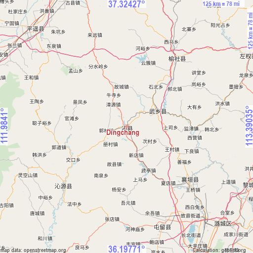
| Upper-left | 37.32427°, | 111.9841° |
| Center: | 36.76306°, | 112.68722° |
| Lower-right: | 36.19771°, | 113.39035° |
| Map W x H: | 125.3×125.3 km | = 77.9×77.9mi |
| max Lat: | 53.31946° ⇑21.4% North |
| Dingchang: | 36.76306° |
| min Lat: | ⇓78.6% South 18.22056° |
| min Long | Dingchang | max Long |
| 75.07348° | 112.68722° | 134.28917° |
| W 40.9%⇐ | ⇒59.1% E |
Elevation
Elevation of Dingchang is 957 m = 3140 ft, and this is 472.2 m = 1549 ft above average elevation for this country.
| Max E: |
5622 m = 18445 ft | 15.4% |
| Dingchang | 957 m 3140 ft | |
| Avg. | 484.8 m = 1591 ft | |
Min E: |
-3 m = -10 ft | 84.6% |
See also: China elevation on elevation.city.
Geographical zone
Dingchang is located in North temperate zone (between Tropic of Cancer and the Arctic Circle). Distance of this Northern Tropic circle is 1481.8 km =920.7 mi to South.| Distance of | km | miles | from Dingchang |
|---|---|---|---|
| North Pole | 5919.4 | 3678.1 | to North |
| Arctic Circle | 3313.5 | 2058.9 | to North |
| Tropic Cancer | 1481.8 | 920.7 | to South |
| Equator | 4087.7 | 2540 | to South |


Nearby cities:
15 places around Dingchang: (largest is in red/bold)
• Changzhi
74.5 km =46.3 mi,  149°
149°
• Danzhu
72.7 km =45.2 mi,  167°
167°
• Daxinzhuang
68.7 km =42.7 mi, 148°
• Fengzhou
17.3 km =10.7 mi,  59°
59°
• Guhan
39.4 km =24.5 mi,  130°
130°
• Gutao
66.6 km =41.4 mi,  317°
317°
• Jicheng
41.2 km =25.6 mi,  35°
35°
• Jiexiu
74.8 km =46.5 mi,  292°
292°
• Liaoyang
67.9 km =42.2 mi, 58°
• Lihou
67.4 km =41.9 mi,  115°
115°
• Linjiang
51.5 km =32 mi,  160°
160°
• Luhua
67.9 km =42.2 mi,  135°
135°
• Mingxing
74.8 km =46.5 mi,  350°
350°
• Qinhe
43.5 km =27 mi,  228°
228°
• Zhaoyu
73.6 km =45.7 mi,  333°
333°
Sources, notices
• [Note1] Compared only with cities in China existing in our database
• [Src1] Map data: © OpenStreetMap contributors (CC-BY-SA)
• [Src2] Other city data from geonames.org with taken over terms of usage.
• [Src3] Geographical zone / Annual Mean Temperature by Robert A. Rohde @ Wikipedia
