Linjiang geodata
Linjiang (Shanxi) is a seat of a third-order administrative division; located in China in Asia/Shanghai (GMT+8) time zone. In our database, there are 1268 cities with bigger population. Compared to other cities in China, 77.8% of cities are located further ↓South; 58.3% of cities are located further →East and 84.1% of cities have lower elevation than Linjiang. Note1


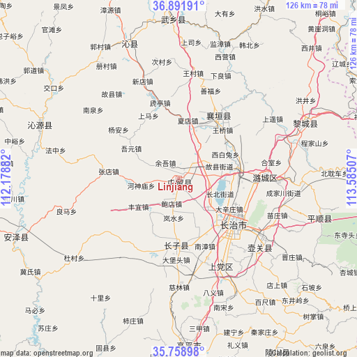
Linjiang GPS coordinates[2]
36° 19' 39" North, 112° 52' 54.984" East
| Map corner | latitude | longitude |
|---|---|---|
| Upper-left | 36.89191°, | 112.17882° |
| Center: | 36.3275°, | 112.88194° |
| Lower-right: | 35.75898°, | 113.58507° |
| Map W x H: | 126×126 km | = 78.3×78.3mi |
| max Lat: | 53.31946° ⇑22.2% North |
| Linjiang: | 36.3275° |
| min Lat: | ⇓77.8% South 18.22056° |
| min Long | Linjiang | max Long |
| 75.07348° | 112.88194° | 134.28917° |
| W 41.7%⇐ | ⇒58.3% E |
Elevation
Elevation of Linjiang is 920 m = 3018 ft, and this is 435.2 m = 1428 ft above average elevation for this country.
| Max E: |
5622 m = 18445 ft | 15.9% |
| Linjiang | 920 m 3018 ft | |
| Avg. | 484.8 m = 1591 ft | |
Min E: |
-3 m = -10 ft | 84.1% |
See also: China elevation on elevation.city.
Geographical zone
Linjiang is located in North temperate zone (between Tropic of Cancer and the Arctic Circle). Distance of this Northern Tropic circle is 1433.3 km =890.6 mi to South.| Distance of | km | miles | from Linjiang |
|---|---|---|---|
| North Pole | 5967.8 | 3708.2 | to North |
| Arctic Circle | 3361.9 | 2089 | to North |
| Tropic Cancer | 1433.3 | 890.6 | to South |
| Equator | 4039.2 | 2509.8 | to South |


Nearby cities:
15 places around Linjiang: (largest is in red/bold)
• Changzhi
25.6 km =15.9 mi,  128°
128°
• Chongwen
69.8 km =43.4 mi,  151°
151°
• Danzhu
22.6 km =14 mi,  184°
184°
• Daxinzhuang
20.9 km =13 mi,  120°
120°
• Dingchang
51.5 km =32 mi,  340°
340°
• Fengzhou
57.3 km =35.6 mi,  357°
357°
• Fucheng
61.5 km =38.2 mi,  250°
250°
• Guhan
26.4 km =16.4 mi,  29°
29°
• Handian
34.5 km =21.4 mi,  155°
155°
• Jicheng
82.1 km =51 mi,  4°
4°
• Lihou
47.8 km =29.7 mi,  65°
65°
• Longquan
35.9 km =22.3 mi, 130°
• Luhua
30.7 km =19.1 mi,  89°
89°
• Qingyang
49.8 km =30.9 mi,  105°
105°
• Qinhe
53.5 km =33.2 mi,  291°
291°
Sources, notices
• [Note1] Compared only with cities in China existing in our database
• [Src1] Map data: © OpenStreetMap contributors (CC-BY-SA)
• [Src2] Other city data from geonames.org with taken over terms of usage.
• [Src3] Geographical zone / Annual Mean Temperature by Robert A. Rohde @ Wikipedia
