Qinting geodata
Qinting (Jiangxi) is a seat of a third-order administrative division; located in China in Asia/Shanghai (GMT+8) time zone. In our database, there are 1268 cities with bigger population. Compared to other cities in China, 78.1% of cities are located further ↑North; 51.7% of cities are located further →East and 50.6% of cities have lower elevation than Qinting. Note1


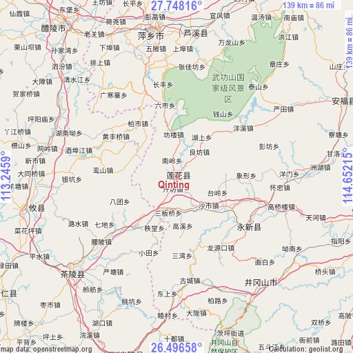
Qinting GPS coordinates[2]
27° 7' 26.832" North, 113° 56' 56.472" East
| Map corner | latitude | longitude |
|---|---|---|
| Upper-left | 27.74816°, | 113.2459° |
| Center: | 27.12412°, | 113.94902° |
| Lower-right: | 26.49658°, | 114.65215° |
| Map W x H: | 139.2×139.2 km | = 86.5×86.5mi |
| max Lat: | 53.31946° ⇑78.1% North |
| Qinting: | 27.12412° |
| min Lat: | ⇓21.9% South 18.22056° |
| min Long | Qinting | max Long |
| 75.07348° | 113.94902° | 134.28917° |
| W 48.3%⇐ | ⇒51.7% E |
Elevation
Elevation of Qinting is 170 m = 558 ft, and this is 314.8 m = 1033 ft below average elevation for this country.
| Max E: |
5622 m = 18445 ft | 49.4% |
| Avg. | 484.8 m = 1591 ft | |
| Qinting | 170 m = 558 ft | |
Min E: |
-3 m = -10 ft | 50.6% |
See also: China elevation on elevation.city.
Geographical zone
Qinting is located in North temperate zone (between Tropic of Cancer and the Arctic Circle). Distance of this Northern Tropic circle is 410 km =254.8 mi to South.| Distance of | km | miles | from Qinting |
|---|---|---|---|
| North Pole | 6991.1 | 4344.1 | to North |
| Arctic Circle | 4385.3 | 2724.9 | to North |
| Tropic Cancer | 410 | 254.8 | to South |
| Equator | 3015.9 | 1874 | to South |


Nearby cities:
15 places around Qinting: (largest is in red/bold)
• Batuan
24.5 km =15.2 mi,  246°
246°
• Gaolong
25.1 km =15.6 mi,  219°
219°
• Gaoshi
27.1 km =16.8 mi,  111°
111°
• Hushang
18.5 km =11.5 mi,  32°
32°
• Liangfang
13.3 km =8.3 mi,  41°
41°
• Litian
22.4 km =13.9 mi,  122°
122°
• Longmen
19.6 km =12.2 mi,  101°
101°
• Longtian
14.1 km =8.8 mi,  145°
145°
• Lukou
23.2 km =14.4 mi, 40°
• Qianshan
30.9 km =19.2 mi, 36°
• Shanshi
21.4 km =13.3 mi, 30°
• Shashi
16.8 km =10.4 mi,  131°
131°
• Tailing
17.2 km =10.7 mi, 111°
• Xiangxing
27.4 km =17 mi,  88°
88°
• Zhitang
22 km =13.7 mi,  203°
203°
Sources, notices
• [Note1] Compared only with cities in China existing in our database
• [Src1] Map data: © OpenStreetMap contributors (CC-BY-SA)
• [Src2] Other city data from geonames.org with taken over terms of usage.
• [Src3] Geographical zone / Annual Mean Temperature by Robert A. Rohde @ Wikipedia
