Qingjiang geodata
Qingjiang (Zhejiang) is a seat of a fourth-order administrative division; located in China in Asia/Shanghai (GMT+8) time zone. In our database, there are 1268 cities with bigger population. Compared to other cities in China, 71.7% of cities are located further ↑North; 88.2% of cities are located further ←West and 94.3% of cities have higher elevation than Qingjiang. Note1


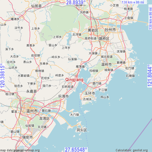
Qingjiang GPS coordinates[2]
28° 16' 35.364" North, 121° 6' 4.572" East
| Map corner | latitude | longitude |
|---|---|---|
| Upper-left | 28.8939°, | 120.39815° |
| Center: | 28.27649°, | 121.10127° |
| Lower-right: | 27.65548°, | 121.8044° |
| Map W x H: | 137.7×137.7 km | = 85.6×85.6mi |
| max Lat: | 53.31946° ⇑71.7% North |
| Qingjiang: | 28.27649° |
| min Lat: | ⇓28.3% South 18.22056° |
| min Long | Qingjiang | max Long |
| 75.07348° | 121.10127° | 134.28917° |
| W 88.2%⇐ | ⇒11.8% E |
Elevation
Elevation of Qingjiang is 7 m = 23 ft, and this is 477.8 m = 1568 ft below average elevation for this country.
| Max E: |
5622 m = 18445 ft | 94.3% |
| Avg. | 484.8 m = 1591 ft | |
| Qingjiang | 7 m = 23 ft | |
Min E: |
-3 m = -10 ft | 5.7% |
See also: China elevation on elevation.city.
Geographical zone
Qingjiang is located in North temperate zone (between Tropic of Cancer and the Arctic Circle). Distance of this Northern Tropic circle is 538.1 km =334.4 mi to South.| Distance of | km | miles | from Qingjiang |
|---|---|---|---|
| North Pole | 6863 | 4264.5 | to North |
| Arctic Circle | 4257.1 | 2645.2 | to North |
| Tropic Cancer | 538.1 | 334.4 | to South |
| Equator | 3144.1 | 1953.7 | to South |


Nearby cities:
15 places around Qingjiang: (largest is in red/bold)
• Dajing
15.6 km =9.7 mi,  19°
19°
• Danxi
11.9 km =7.4 mi,  245°
245°
• Furong
7.2 km =4.5 mi,  289°
289°
• Haishan
8.5 km =5.3 mi,  132°
132°
• Hongqiao
9.4 km =5.8 mi,  229°
229°
• Lingdi
15 km =9.3 mi,  274°
274°
• Longxi
14.4 km =8.9 mi,  336°
336°
• Nanyue
10.3 km =6.4 mi,  191°
191°
• Puqi
13.1 km =8.1 mi,  201°
201°
• Shifan
12.1 km =7.5 mi,  220°
220°
• Shuangfeng
16.1 km =10 mi,  9°
9°
• Sidu
15.9 km =9.9 mi, 245°
• Tiancheng
13.6 km =8.5 mi,  210°
210°
• Yandang
9.5 km =5.9 mi, 23°
• Yanhu
10.2 km =6.3 mi, 291°
Sources, notices
• [Note1] Compared only with cities in China existing in our database
• [Src1] Map data: © OpenStreetMap contributors (CC-BY-SA)
• [Src2] Other city data from geonames.org with taken over terms of usage.
• [Src3] Geographical zone / Annual Mean Temperature by Robert A. Rohde @ Wikipedia
