Longxi geodata
Longxi (Zhejiang) is a seat of a fourth-order administrative division; located in China in Asia/Shanghai (GMT+8) time zone. In our database, there are 1268 cities with bigger population. Compared to other cities in China, 70.7% of cities are located further ↑North; 87.9% of cities are located further ←West and 62.6% of cities have higher elevation than Longxi. Note1


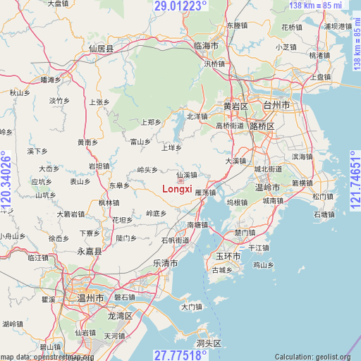
Longxi GPS coordinates[2]
28° 23' 43.836" North, 121° 2' 36.168" East
| Map corner | latitude | longitude |
|---|---|---|
| Upper-left | 29.01223°, | 120.34026° |
| Center: | 28.39551°, | 121.04338° |
| Lower-right: | 27.77518°, | 121.74651° |
| Map W x H: | 137.5×137.5 km | = 85.4×85.4mi |
| max Lat: | 53.31946° ⇑70.7% North |
| Longxi: | 28.39551° |
| min Lat: | ⇓29.3% South 18.22056° |
| min Long | Longxi | max Long |
| 75.07348° | 121.04338° | 134.28917° |
| W 87.9%⇐ | ⇒12.1% E |
Elevation
Elevation of Longxi is 84 m = 276 ft, and this is 400.8 m = 1315 ft below average elevation for this country.
| Max E: |
5622 m = 18445 ft | 62.6% |
| Avg. | 484.8 m = 1591 ft | |
| Longxi | 84 m = 276 ft | |
Min E: |
-3 m = -10 ft | 37.4% |
See also: China elevation on elevation.city.
Geographical zone
Longxi is located in North temperate zone (between Tropic of Cancer and the Arctic Circle). Distance of this Northern Tropic circle is 551.4 km =342.6 mi to South.| Distance of | km | miles | from Longxi |
|---|---|---|---|
| North Pole | 6849.8 | 4256.3 | to North |
| Arctic Circle | 4243.9 | 2637 | to North |
| Tropic Cancer | 551.4 | 342.6 | to South |
| Equator | 3157.3 | 1961.9 | to South |


Nearby cities:
15 places around Longxi: (largest is in red/bold)
• Dajing
10.9 km =6.8 mi,  81°
81°
• Furong
10.8 km =6.7 mi,  186°
186°
• Fuxi
8.1 km =5 mi,  342°
342°
• Huwu
15.7 km =9.8 mi,  89°
89°
• Lingdi
15.3 km =9.5 mi,  217°
217°
• Lingtou
13.4 km =8.3 mi,  289°
289°
• Pingtian
16.7 km =10.4 mi,  9°
9°
• Qingjiang
14.4 km =8.9 mi,  156°
156°
• Shangyang
14.4 km =8.9 mi, 343°
• Shuangfeng
8.6 km =5.3 mi,  71°
71°
• Xianxi
3.3 km =2.1 mi,  42°
42°
• Yandang
10.5 km =6.5 mi,  115°
115°
• Yanhu
10.2 km =6.3 mi,  202°
202°
• Zhen’an
14.1 km =8.8 mi,  55°
55°
• Zhiren
12.9 km =8 mi,  34°
34°
Sources, notices
• [Note1] Compared only with cities in China existing in our database
• [Src1] Map data: © OpenStreetMap contributors (CC-BY-SA)
• [Src2] Other city data from geonames.org with taken over terms of usage.
• [Src3] Geographical zone / Annual Mean Temperature by Robert A. Rohde @ Wikipedia
