Lingdi geodata
Lingdi (Zhejiang) is a seat of a fourth-order administrative division; located in China in Asia/Shanghai (GMT+8) time zone. In our database, there are 1268 cities with bigger population. Compared to other cities in China, 71.6% of cities are located further ↑North; 87.6% of cities are located further ←West and 60.1% of cities have lower elevation than Lingdi. Note1


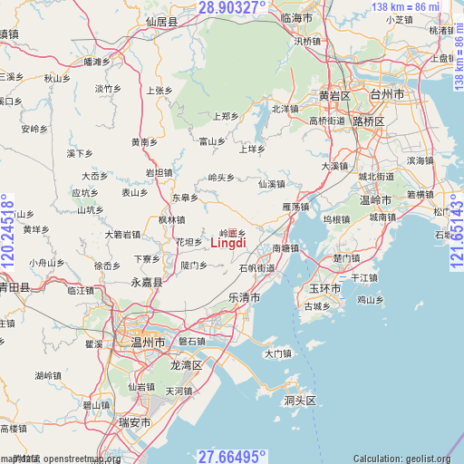
Lingdi GPS coordinates[2]
28° 17' 9.276" North, 120° 56' 53.88" East
| Map corner | latitude | longitude |
|---|---|---|
| Upper-left | 28.90327°, | 120.24518° |
| Center: | 28.28591°, | 120.9483° |
| Lower-right: | 27.66495°, | 121.65143° |
| Map W x H: | 137.7×137.7 km | = 85.6×85.6mi |
| max Lat: | 53.31946° ⇑71.6% North |
| Lingdi: | 28.28591° |
| min Lat: | ⇓28.4% South 18.22056° |
| min Long | Lingdi | max Long |
| 75.07348° | 120.9483° | 134.28917° |
| W 87.6%⇐ | ⇒12.4% E |
Elevation
Elevation of Lingdi is 260 m = 853 ft, and this is 224.8 m = 738 ft below average elevation for this country.
| Max E: |
5622 m = 18445 ft | 39.9% |
| Avg. | 484.8 m = 1591 ft | |
| Lingdi | 260 m = 853 ft | |
Min E: |
-3 m = -10 ft | 60.1% |
See also: China elevation on elevation.city.
Geographical zone
Lingdi is located in North temperate zone (between Tropic of Cancer and the Arctic Circle). Distance of this Northern Tropic circle is 539.2 km =335 mi to South.| Distance of | km | miles | from Lingdi |
|---|---|---|---|
| North Pole | 6862 | 4263.8 | to North |
| Arctic Circle | 4256.1 | 2644.6 | to North |
| Tropic Cancer | 539.2 | 335 | to South |
| Equator | 3145.1 | 1954.3 | to South |


Nearby cities:
15 places around Lingdi: (largest is in red/bold)
• Chengbei
14.2 km =8.8 mi,  196°
196°
• Danxi
7.3 km =4.5 mi,  145°
145°
• Doumen
14.8 km =9.2 mi,  230°
230°
• Furong
8.3 km =5.2 mi,  80°
80°
• Hesheng
14.9 km =9.3 mi,  311°
311°
• Hongqiao
10.6 km =6.6 mi,  132°
132°
• Huatan
13.2 km =8.2 mi,  258°
258°
• Lingtou
16.9 km =10.5 mi,  348°
348°
• Longxi
15.3 km =9.5 mi,  37°
37°
• Puqi
16.7 km =10.4 mi,  142°
142°
• Qingjiang
15 km =9.3 mi,  94°
94°
• Shifan
12.5 km =7.8 mi, 145°
• Sidu
7.8 km =4.8 mi,  175°
175°
• Tiancheng
15.1 km =9.4 mi, 147°
• Yanhu
6.1 km =3.8 mi,  63°
63°
Sources, notices
• [Note1] Compared only with cities in China existing in our database
• [Src1] Map data: © OpenStreetMap contributors (CC-BY-SA)
• [Src2] Other city data from geonames.org with taken over terms of usage.
• [Src3] Geographical zone / Annual Mean Temperature by Robert A. Rohde @ Wikipedia
