Qiangbai geodata
Qiangbai (Shaanxi) is a seat of a fourth-order administrative division; located in China in Asia/Shanghai (GMT+8) time zone. In our database, there are 1268 cities with bigger population. Compared to other cities in China, 74% of cities are located further ↓South; 72.2% of cities are located further →East and 67.1% of cities have lower elevation than Qiangbai. Note1


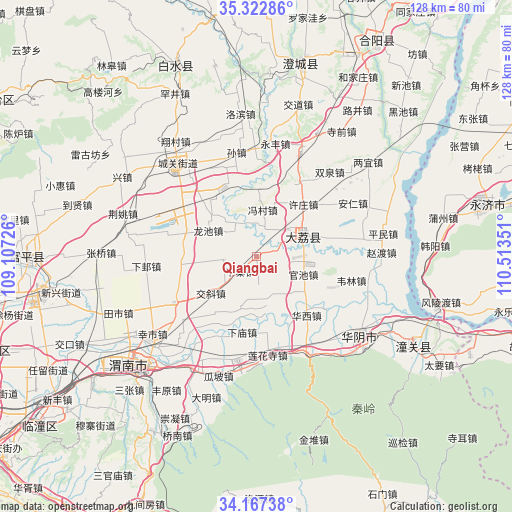
Qiangbai GPS coordinates[2]
34° 44' 49.704" North, 109° 48' 37.368" East
| Map corner | latitude | longitude |
|---|---|---|
| Upper-left | 35.32286°, | 109.10726° |
| Center: | 34.74714°, | 109.81038° |
| Lower-right: | 34.16738°, | 110.51351° |
| Map W x H: | 128.5×128.5 km | = 79.8×79.8mi |
| max Lat: | 53.31946° ⇑26% North |
| Qiangbai: | 34.74714° |
| min Lat: | ⇓74% South 18.22056° |
| min Long | Qiangbai | max Long |
| 75.07348° | 109.81038° | 134.28917° |
| W 27.8%⇐ | ⇒72.2% E |
Elevation
Elevation of Qiangbai is 361 m = 1184 ft, and this is 123.8 m = 406 ft below average elevation for this country.
| Max E: |
5622 m = 18445 ft | 32.9% |
| Avg. | 484.8 m = 1591 ft | |
| Qiangbai | 361 m = 1184 ft | |
Min E: |
-3 m = -10 ft | 67.1% |
See also: China elevation on elevation.city.
Geographical zone
Qiangbai is located in North temperate zone (between Tropic of Cancer and the Arctic Circle). Distance of this Northern Tropic circle is 1257.6 km =781.4 mi to South.| Distance of | km | miles | from Qiangbai |
|---|---|---|---|
| North Pole | 6143.5 | 3817.4 | to North |
| Arctic Circle | 3537.7 | 2198.2 | to North |
| Tropic Cancer | 1257.6 | 781.4 | to South |
| Equator | 3863.5 | 2400.7 | to South |


Nearby cities:
15 places around Qiangbai: (largest is in red/bold)
• Dali
12.9 km =8 mi,  65°
65°
• Duanjia
14 km =8.7 mi,  3°
3°
• Fengcun
11.8 km =7.3 mi,  7°
7°
• Guanchi
12.8 km =8 mi,  112°
112°
• Guanlu
8.2 km =5.1 mi,  262°
262°
• Jiaoxie
14.6 km =9.1 mi,  231°
231°
• Longchi
13.9 km =8.6 mi,  298°
298°
• Longyang
15.7 km =9.8 mi,  314°
314°
• Nianqiao
8.2 km =5.1 mi,  34°
34°
• Shicao
12 km =7.5 mi,  88°
88°
• Sucun
12.3 km =7.6 mi,  162°
162°
• Xiaoyi
17.4 km =10.8 mi,  214°
214°
• Xiazhai
5.5 km =3.4 mi, 228°
• Xuzhuang
17.6 km =10.9 mi,  42°
42°
• Zhangjia
16 km =9.9 mi, 205°
Sources, notices
• [Note1] Compared only with cities in China existing in our database
• [Src1] Map data: © OpenStreetMap contributors (CC-BY-SA)
• [Src2] Other city data from geonames.org with taken over terms of usage.
• [Src3] Geographical zone / Annual Mean Temperature by Robert A. Rohde @ Wikipedia
