Pingshui geodata
Pingshui (Zhejiang) is a seat of a fourth-order administrative division; located in China in Asia/Shanghai (GMT+8) time zone. In our database, there are 1268 cities with bigger population. Compared to other cities in China, 55.2% of cities are located further ↑North; 85.8% of cities are located further ←West and 85.5% of cities have higher elevation than Pingshui. Note1


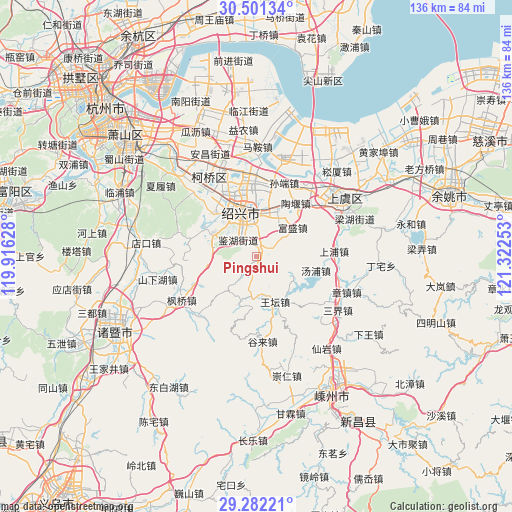
Pingshui GPS coordinates[2]
29° 53' 37.104" North, 120° 37' 9.84" East
| Map corner | latitude | longitude |
|---|---|---|
| Upper-left | 30.50134°, | 119.91628° |
| Center: | 29.89364°, | 120.6194° |
| Lower-right: | 29.28221°, | 121.32253° |
| Map W x H: | 135.6×135.6 km | = 84.3×84.3mi |
| max Lat: | 53.31946° ⇑55.2% North |
| Pingshui: | 29.89364° |
| min Lat: | ⇓44.8% South 18.22056° |
| min Long | Pingshui | max Long |
| 75.07348° | 120.6194° | 134.28917° |
| W 85.8%⇐ | ⇒14.2% E |
Elevation
Elevation of Pingshui is 15 m = 49 ft, and this is 469.8 m = 1541 ft below average elevation for this country.
| Max E: |
5622 m = 18445 ft | 85.5% |
| Avg. | 484.8 m = 1591 ft | |
| Pingshui | 15 m = 49 ft | |
Min E: |
-3 m = -10 ft | 14.5% |
See also: China elevation on elevation.city.
Geographical zone
Pingshui is located in North temperate zone (between Tropic of Cancer and the Arctic Circle). Distance of this Northern Tropic circle is 717.9 km =446.1 mi to South.| Distance of | km | miles | from Pingshui |
|---|---|---|---|
| North Pole | 6683.2 | 4152.7 | to North |
| Arctic Circle | 4077.3 | 2533.5 | to North |
| Tropic Cancer | 717.9 | 446.1 | to South |
| Equator | 3323.9 | 2065.4 | to South |


Nearby cities:
15 places around Pingshui: (largest is in red/bold)
• Chengnan
10.1 km =6.3 mi,  330°
330°
• Donghu
14.7 km =9.1 mi,  355°
355°
• Fushan
13 km =8.1 mi, 333°
• Fusheng
12.4 km =7.7 mi,  51°
51°
• Gaobu
13.6 km =8.5 mi,  18°
18°
• Jianhu
10.7 km =6.6 mi, 334°
• Jinsanjiao
13.9 km =8.6 mi,  320°
320°
• Jishan
8.6 km =5.3 mi,  350°
350°
• Lingzhi
15.6 km =9.7 mi,  343°
343°
• Lizhu
16.2 km =10.1 mi,  294°
294°
• Shaoxing
12.7 km =7.9 mi, 342°
• Tangpu
16.3 km =10.1 mi,  102°
102°
• Taoyan
17.6 km =10.9 mi,  36°
36°
• Wangtan
12.9 km =8 mi,  156°
156°
• Zhutiantou
13.6 km =8.5 mi,  196°
196°
Sources, notices
• [Note1] Compared only with cities in China existing in our database
• [Src1] Map data: © OpenStreetMap contributors (CC-BY-SA)
• [Src2] Other city data from geonames.org with taken over terms of usage.
• [Src3] Geographical zone / Annual Mean Temperature by Robert A. Rohde @ Wikipedia
