Tangpu geodata
Tangpu (Zhejiang) is a seat of a fourth-order administrative division; located in China in Asia/Shanghai (GMT+8) time zone. In our database, there are 1268 cities with bigger population. Compared to other cities in China, 55.6% of cities are located further ↑North; 86.7% of cities are located further ←West and 84.9% of cities have higher elevation than Tangpu. Note1


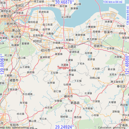
Tangpu GPS coordinates[2]
29° 51' 39.132" North, 120° 47' 1.428" East
| Map corner | latitude | longitude |
|---|---|---|
| Upper-left | 30.46878°, | 120.08061° |
| Center: | 29.86087°, | 120.78373° |
| Lower-right: | 29.24924°, | 121.48686° |
| Map W x H: | 135.6×135.6 km | = 84.3×84.3mi |
| max Lat: | 53.31946° ⇑55.6% North |
| Tangpu: | 29.86087° |
| min Lat: | ⇓44.4% South 18.22056° |
| min Long | Tangpu | max Long |
| 75.07348° | 120.78373° | 134.28917° |
| W 86.7%⇐ | ⇒13.3% E |
Elevation
Elevation of Tangpu is 16 m = 52 ft, and this is 468.8 m = 1538 ft below average elevation for this country.
| Max E: |
5622 m = 18445 ft | 84.9% |
| Avg. | 484.8 m = 1591 ft | |
| Tangpu | 16 m = 52 ft | |
Min E: |
-3 m = -10 ft | 15.1% |
See also: China elevation on elevation.city.
Geographical zone
Tangpu is located in North temperate zone (between Tropic of Cancer and the Arctic Circle). Distance of this Northern Tropic circle is 714.3 km =443.8 mi to South.| Distance of | km | miles | from Tangpu |
|---|---|---|---|
| North Pole | 6686.8 | 4155 | to North |
| Arctic Circle | 4081 | 2535.8 | to North |
| Tropic Cancer | 714.3 | 443.8 | to South |
| Equator | 3320.2 | 2063.1 | to South |


Nearby cities:
15 places around Tangpu: (largest is in red/bold)
• Changtang
10.5 km =6.5 mi,  4°
4°
• Daoxu
20.7 km =12.9 mi,  355°
355°
• Dongguan
17 km =10.6 mi,  9°
9°
• Fusheng
12.9 km =8 mi,  331°
331°
• Gaobu
20.1 km =12.5 mi, 325°
• Haoba
12.2 km =7.6 mi,  30°
30°
• Lianghu
18.3 km =11.4 mi,  37°
37°
• Pingshui
16.3 km =10.1 mi,  282°
282°
• Sanjie
12.9 km =8 mi,  151°
151°
• Shangpu
6.9 km =4.3 mi, 41°
• Shangyu
19.1 km =11.9 mi, 26°
• Taoyan
18.6 km =11.6 mi,  343°
343°
• Wangtan
13.6 km =8.5 mi,  232°
232°
• Xianyan
20.8 km =12.9 mi,  172°
172°
• Zhangzhen
10 km =6.2 mi,  125°
125°
Sources, notices
• [Note1] Compared only with cities in China existing in our database
• [Src1] Map data: © OpenStreetMap contributors (CC-BY-SA)
• [Src2] Other city data from geonames.org with taken over terms of usage.
• [Src3] Geographical zone / Annual Mean Temperature by Robert A. Rohde @ Wikipedia
