Pinghai geodata
Pinghai (Fujian) is a seat of a fourth-order administrative division; located in China in Asia/Shanghai (GMT+8) time zone. In our database, there are 1268 cities with bigger population. Compared to other cities in China, 85.6% of cities are located further ↑North; 77.3% of cities are located further ←West and 79.8% of cities have higher elevation than Pinghai. Note1


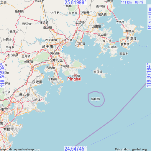
Pinghai GPS coordinates[2]
25° 11' 7.368" North, 119° 16' 6.636" East
| Map corner | latitude | longitude |
|---|---|---|
| Upper-left | 25.81999°, | 118.56539° |
| Center: | 25.18538°, | 119.26851° |
| Lower-right: | 24.54745°, | 119.97164° |
| Map W x H: | 141.5×141.5 km | = 87.9×87.9mi |
| max Lat: | 53.31946° ⇑85.6% North |
| Pinghai: | 25.18538° |
| min Lat: | ⇓14.4% South 18.22056° |
| min Long | Pinghai | max Long |
| 75.07348° | 119.26851° | 134.28917° |
| W 77.3%⇐ | ⇒22.7% E |
Elevation
Elevation of Pinghai is 27 m = 89 ft, and this is 457.8 m = 1502 ft below average elevation for this country.
| Max E: |
5622 m = 18445 ft | 79.8% |
| Avg. | 484.8 m = 1591 ft | |
| Pinghai | 27 m = 89 ft | |
Min E: |
-3 m = -10 ft | 20.2% |
See also: China elevation on elevation.city.
Geographical zone
Pinghai is located in North temperate zone (between Tropic of Cancer and the Arctic Circle). Distance of this Northern Tropic circle is 194.4 km =120.8 mi to South.| Distance of | km | miles | from Pinghai |
|---|---|---|---|
| North Pole | 7206.7 | 4478 | to North |
| Arctic Circle | 4600.8 | 2858.8 | to North |
| Tropic Cancer | 194.4 | 120.8 | to South |
| Equator | 2800.4 | 1740.1 | to South |


Nearby cities:
15 places around Pinghai: (largest is in red/bold)
• Baitang
34.3 km =21.3 mi,  329°
329°
• Beigao
21.8 km =13.5 mi,  322°
322°
• Daitou
9.1 km =5.7 mi, 332°
• Dongjiao
13.7 km =8.5 mi,  311°
311°
• Huangshi
29.1 km =18.1 mi, 317°
• Hushi
23.3 km =14.5 mi, 309°
• Jiangkou
34.3 km =21.3 mi,  348°
348°
• Jiangyin
30.9 km =19.2 mi,  8°
8°
• Lingchuan
33.2 km =20.6 mi,  291°
291°
• Nanri
21.4 km =13.3 mi,  80°
80°
• Sanjiangkou
32.5 km =20.2 mi, 331°
• Xindu
33.2 km =20.6 mi, 315°
• Xiuyu
24.8 km =15.4 mi, 288°
• Yuetang
18.7 km =11.6 mi, 288°
• Zhongmen
18.9 km =11.7 mi,  272°
272°
Sources, notices
• [Note1] Compared only with cities in China existing in our database
• [Src1] Map data: © OpenStreetMap contributors (CC-BY-SA)
• [Src2] Other city data from geonames.org with taken over terms of usage.
• [Src3] Geographical zone / Annual Mean Temperature by Robert A. Rohde @ Wikipedia
