Pingding geodata
Pingding (Guangdong) is a seat of a fourth-order administrative division; located in China in Asia/Urumqi (GMT+6) time zone. In our database, there are 1268 cities with bigger population. Compared to other cities in China, 97.2% of cities are located further ↑North; 69.5% of cities are located further →East and 68.2% of cities have higher elevation than Pingding. Note1


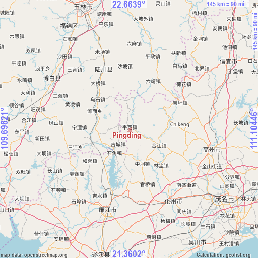
Pingding GPS coordinates[2]
22° 0' 48.78" North, 110° 24' 4.788" East
| Map corner | latitude | longitude |
|---|---|---|
| Upper-left | 22.6639°, | 109.69821° |
| Center: | 22.01355°, | 110.40133° |
| Lower-right: | 21.3602°, | 111.10446° |
| Map W x H: | 145×145 km | = 90.1×90.1mi |
| max Lat: | 53.31946° ⇑97.2% North |
| Pingding: | 22.01355° |
| min Lat: | ⇓2.8% South 18.22056° |
| min Long | Pingding | max Long |
| 75.07348° | 110.40133° | 134.28917° |
| W 30.5%⇐ | ⇒69.5% E |
Elevation
Elevation of Pingding is 59 m = 194 ft, and this is 425.8 m = 1397 ft below average elevation for this country.
| Max E: |
5622 m = 18445 ft | 68.2% |
| Avg. | 484.8 m = 1591 ft | |
| Pingding | 59 m = 194 ft | |
Min E: |
-3 m = -10 ft | 31.8% |
See also: China elevation on elevation.city.
Geographical zone
Pingding is located in North Torrid zone (between Equator and Tropic of Cancer). Distance of this Northern Tropic circle is 158.2 km =98.3 mi to North.| Distance of | km | miles | from Pingding |
|---|---|---|---|
| North Pole | 7559.4 | 4697.2 | to North |
| Arctic Circle | 4953.5 | 3078 | to North |
| Tropic Cancer | 158.2 | 98.3 | to North |
| Equator | 2447.7 | 1520.9 | to South |


Nearby cities:
15 places around Pingding: (largest is in red/bold)
• Baoxu
32.2 km =20 mi,  62°
62°
• Boyang
22.7 km =14.1 mi, 62°
• Guanqiao
32.5 km =20.2 mi,  162°
162°
• Hejiang
18.4 km =11.4 mi,  118°
118°
• Heliao
27.9 km =17.3 mi,  231°
231°
• Hetang
32.1 km =19.9 mi,  90°
90°
• Jianghu
26.3 km =16.3 mi,  127°
127°
• Linchen
27 km =16.8 mi,  138°
138°
• Nawu
19.2 km =11.9 mi, 93°
• Shatian
35 km =21.7 mi,  110°
110°
• Shiban
35.8 km =22.2 mi, 64°
• Shijiao
17.6 km =10.9 mi,  212°
212°
• Wenlou
9.2 km =5.7 mi,  13°
13°
• Zhenjiang
35.3 km =21.9 mi, 117°
• Zhongdong
20.8 km =12.9 mi, 160°
Sources, notices
• [Note1] Compared only with cities in China existing in our database
• [Src1] Map data: © OpenStreetMap contributors (CC-BY-SA)
• [Src2] Other city data from geonames.org with taken over terms of usage.
• [Src3] Geographical zone / Annual Mean Temperature by Robert A. Rohde @ Wikipedia
