Boyang geodata
Boyang (Guangdong) is a seat of a fourth-order administrative division; located in China in Asia/Urumqi (GMT+6) time zone. In our database, there are 1268 cities with bigger population. Compared to other cities in China, 97.1% of cities are located further ↑North; 68.7% of cities are located further →East and 66.4% of cities have higher elevation than Boyang. Note1


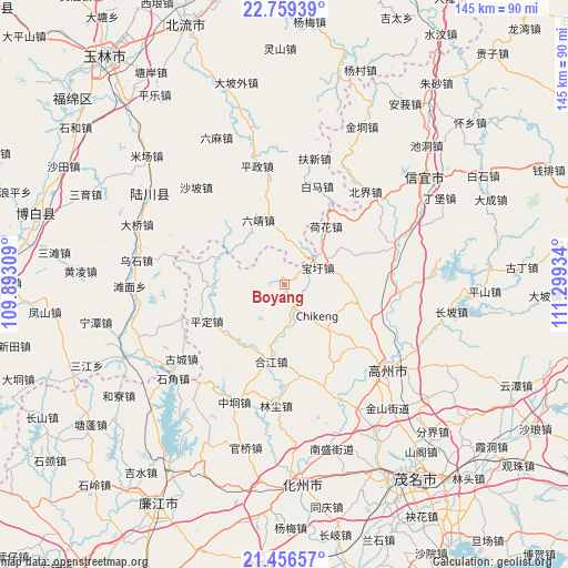
Boyang GPS coordinates[2]
22° 6' 34.128" North, 110° 35' 46.356" East
| Map corner | latitude | longitude |
|---|---|---|
| Upper-left | 22.75939°, | 109.89309° |
| Center: | 22.10948°, | 110.59621° |
| Lower-right: | 21.45657°, | 111.29934° |
| Map W x H: | 144.9×144.9 km | = 90×90mi |
| max Lat: | 53.31946° ⇑97.1% North |
| Boyang: | 22.10948° |
| min Lat: | ⇓2.9% South 18.22056° |
| min Long | Boyang | max Long |
| 75.07348° | 110.59621° | 134.28917° |
| W 31.3%⇐ | ⇒68.7% E |
Elevation
Elevation of Boyang is 67 m = 220 ft, and this is 417.8 m = 1371 ft below average elevation for this country.
| Max E: |
5622 m = 18445 ft | 66.4% |
| Avg. | 484.8 m = 1591 ft | |
| Boyang | 67 m = 220 ft | |
Min E: |
-3 m = -10 ft | 33.6% |
See also: China elevation on elevation.city.
Geographical zone
Boyang is located in North Torrid zone (between Equator and Tropic of Cancer). Distance of this Northern Tropic circle is 147.6 km =91.7 mi to North.| Distance of | km | miles | from Boyang |
|---|---|---|---|
| North Pole | 7548.7 | 4690.5 | to North |
| Arctic Circle | 4942.8 | 3071.3 | to North |
| Tropic Cancer | 147.6 | 91.7 | to North |
| Equator | 2458.3 | 1527.5 | to South |


Nearby cities:
15 places around Boyang: (largest is in red/bold)
• Baoxu
9.5 km =5.9 mi,  62°
62°
• Dajing
28.5 km =17.7 mi,  95°
95°
• Hehua
18.2 km =11.3 mi,  36°
36°
• Hejiang
19.8 km =12.3 mi,  191°
191°
• Hetang
16.3 km =10.1 mi,  132°
132°
• Jianghu
26.5 km =16.5 mi,  178°
178°
• Nantang
20.6 km =12.8 mi, 104°
• Nawu
11.8 km =7.3 mi, 184°
• Pingding
22.7 km =14.1 mi,  242°
242°
• Shatian
26 km =16.2 mi,  150°
150°
• Shiban
13.1 km =8.1 mi,  68°
68°
• Tantou
28.1 km =17.5 mi, 72°
• Wenlou
18.1 km =11.2 mi,  264°
264°
• Zhenjiang
29.1 km =18.1 mi,  157°
157°
• Zhenlong
30.8 km =19.1 mi, 68°
Sources, notices
• [Note1] Compared only with cities in China existing in our database
• [Src1] Map data: © OpenStreetMap contributors (CC-BY-SA)
• [Src2] Other city data from geonames.org with taken over terms of usage.
• [Src3] Geographical zone / Annual Mean Temperature by Robert A. Rohde @ Wikipedia
