Pingchuan geodata
Pingchuan (Fujian) is a seat of a third-order administrative division; located in China in Asia/Shanghai (GMT+8) time zone. In our database, there are 1268 cities with bigger population. Compared to other cities in China, 85.9% of cities are located further ↑North; 60.6% of cities are located further ←West and 61.1% of cities have lower elevation than Pingchuan. Note1


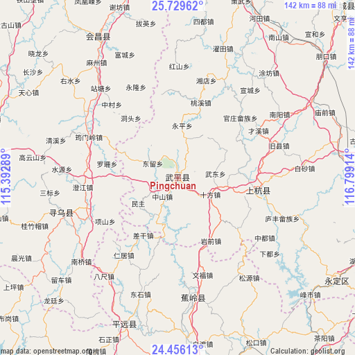
Pingchuan GPS coordinates[2]
25° 5' 40.308" North, 116° 5' 45.636" East
| Map corner | latitude | longitude |
|---|---|---|
| Upper-left | 25.72962°, | 115.39289° |
| Center: | 25.09453°, | 116.09601° |
| Lower-right: | 24.45613°, | 116.79914° |
| Map W x H: | 141.6×141.6 km | = 88×88mi |
| max Lat: | 53.31946° ⇑85.9% North |
| Pingchuan: | 25.09453° |
| min Lat: | ⇓14.1% South 18.22056° |
| min Long | Pingchuan | max Long |
| 75.07348° | 116.09601° | 134.28917° |
| W 60.6%⇐ | ⇒39.4% E |
Elevation
Elevation of Pingchuan is 273 m = 896 ft, and this is 211.8 m = 695 ft below average elevation for this country.
| Max E: |
5622 m = 18445 ft | 38.9% |
| Avg. | 484.8 m = 1591 ft | |
| Pingchuan | 273 m = 896 ft | |
Min E: |
-3 m = -10 ft | 61.1% |
See also: China elevation on elevation.city.
Geographical zone
Pingchuan is located in North temperate zone (between Tropic of Cancer and the Arctic Circle). Distance of this Northern Tropic circle is 184.3 km =114.5 mi to South.| Distance of | km | miles | from Pingchuan |
|---|---|---|---|
| North Pole | 7216.8 | 4484.3 | to North |
| Arctic Circle | 4610.9 | 2865.1 | to North |
| Tropic Cancer | 184.3 | 114.5 | to South |
| Equator | 2790.3 | 1733.8 | to South |


Nearby cities:
15 places around Pingchuan: (largest is in red/bold)
• Chagan
26.9 km =16.7 mi,  210°
210°
• Dongliu
12.1 km =7.5 mi,  297°
297°
• Huyang
23.2 km =14.4 mi,  104°
104°
• Laocheng
9.6 km =6 mi,  219°
219°
• Minzhu
18.8 km =11.7 mi,  236°
236°
• Qifang
0.7 km =0.4 mi,  29°
29°
• Shanhu
27.8 km =17.3 mi,  56°
56°
• Shifang
14.5 km =9 mi,  117°
117°
• Wan’an
4.5 km =2.8 mi,  354°
354°
• Wudong
15.2 km =9.4 mi,  83°
83°
• Xiaba
24.6 km =15.3 mi,  193°
193°
• Yanqian
28.1 km =17.5 mi,  152°
152°
• Yongping
20.9 km =13 mi,  5°
5°
• Zhongbao
20.4 km =12.7 mi, 56°
• Zhongchi
19.1 km =11.9 mi,  169°
169°
Sources, notices
• [Note1] Compared only with cities in China existing in our database
• [Src1] Map data: © OpenStreetMap contributors (CC-BY-SA)
• [Src2] Other city data from geonames.org with taken over terms of usage.
• [Src3] Geographical zone / Annual Mean Temperature by Robert A. Rohde @ Wikipedia
