Minzhu geodata
Minzhu (Fujian) is a seat of a fourth-order administrative division; located in China in Asia/Shanghai (GMT+8) time zone. In our database, there are 1268 cities with bigger population. Compared to other cities in China, 86.4% of cities are located further ↑North; 59.7% of cities are located further ←West and 65.6% of cities have lower elevation than Minzhu. Note1


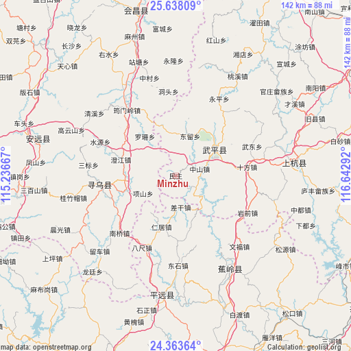
Minzhu GPS coordinates[2]
25° 0' 9.072" North, 115° 56' 23.244" East
| Map corner | latitude | longitude |
|---|---|---|
| Upper-left | 25.63809°, | 115.23667° |
| Center: | 25.00252°, | 115.93979° |
| Lower-right: | 24.36364°, | 116.64292° |
| Map W x H: | 141.7×141.7 km | = 88×88mi |
| max Lat: | 53.31946° ⇑86.4% North |
| Minzhu: | 25.00252° |
| min Lat: | ⇓13.6% South 18.22056° |
| min Long | Minzhu | max Long |
| 75.07348° | 115.93979° | 134.28917° |
| W 59.7%⇐ | ⇒40.3% E |
Elevation
Elevation of Minzhu is 336 m = 1102 ft, and this is 148.8 m = 488 ft below average elevation for this country.
| Max E: |
5622 m = 18445 ft | 34.4% |
| Avg. | 484.8 m = 1591 ft | |
| Minzhu | 336 m = 1102 ft | |
Min E: |
-3 m = -10 ft | 65.6% |
See also: China elevation on elevation.city.
Geographical zone
Minzhu is located in North temperate zone (between Tropic of Cancer and the Arctic Circle). Distance of this Northern Tropic circle is 174.1 km =108.2 mi to South.| Distance of | km | miles | from Minzhu |
|---|---|---|---|
| North Pole | 7227 | 4490.6 | to North |
| Arctic Circle | 4621.2 | 2871.5 | to North |
| Tropic Cancer | 174.1 | 108.2 | to South |
| Equator | 2780 | 1727.4 | to South |


Nearby cities:
15 places around Minzhu: (largest is in red/bold)
• Chagan
13 km =8.1 mi,  171°
171°
• Chengjiang
23.1 km =14.4 mi,  286°
286°
• Dongliu
16.5 km =10.3 mi,  17°
17°
• Huangshe
24.1 km =15 mi,  205°
205°
• Jitan
20.7 km =12.9 mi,  253°
253°
• Laocheng
10.1 km =6.3 mi,  74°
74°
• Luoshan
20.1 km =12.5 mi,  321°
321°
• Pingchuan
18.8 km =11.7 mi,  56°
56°
• Qifang
19.4 km =12.1 mi, 56°
• Renju
21.4 km =13.3 mi,  195°
195°
• Shangju
24.3 km =15.1 mi, 169°
• Wan’an
21.3 km =13.2 mi,  46°
46°
• Xiaba
16.8 km =10.4 mi,  144°
144°
• Xiangshan
15 km =9.3 mi,  241°
241°
• Zhongchi
21.1 km =13.1 mi,  114°
114°
Sources, notices
• [Note1] Compared only with cities in China existing in our database
• [Src1] Map data: © OpenStreetMap contributors (CC-BY-SA)
• [Src2] Other city data from geonames.org with taken over terms of usage.
• [Src3] Geographical zone / Annual Mean Temperature by Robert A. Rohde @ Wikipedia
