Pingchao geodata
Pingchao (Jiangsu) is a seat of a fourth-order administrative division; located in China in Asia/Shanghai (GMT+8) time zone. In our database, there are 1268 cities with bigger population. Compared to other cities in China, 61.8% of cities are located further ↓South; 86.5% of cities are located further ←West and 95.9% of cities have higher elevation than Pingchao. Note1


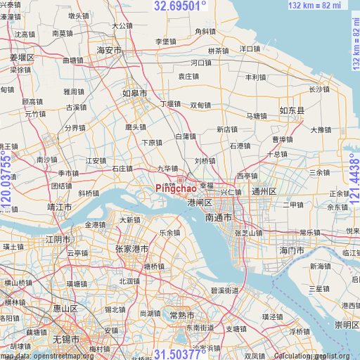
Pingchao GPS coordinates[2]
32° 6' 4.788" North, 120° 44' 26.412" East
| Map corner | latitude | longitude |
|---|---|---|
| Upper-left | 32.69501°, | 120.03755° |
| Center: | 32.10133°, | 120.74067° |
| Lower-right: | 31.50377°, | 121.4438° |
| Map W x H: | 132.5×132.5 km | = 82.3×82.3mi |
| max Lat: | 53.31946° ⇑38.2% North |
| Pingchao: | 32.10133° |
| min Lat: | ⇓61.8% South 18.22056° |
| min Long | Pingchao | max Long |
| 75.07348° | 120.74067° | 134.28917° |
| W 86.5%⇐ | ⇒13.5% E |
Elevation
Elevation of Pingchao is 6 m = 20 ft, and this is 478.8 m = 1571 ft below average elevation for this country.
| Max E: |
5622 m = 18445 ft | 95.9% |
| Avg. | 484.8 m = 1591 ft | |
| Pingchao | 6 m = 20 ft | |
Min E: |
-3 m = -10 ft | 4.1% |
See also: China elevation on elevation.city.
Geographical zone
Pingchao is located in North temperate zone (between Tropic of Cancer and the Arctic Circle). Distance of this Northern Tropic circle is 963.4 km =598.6 mi to South.| Distance of | km | miles | from Pingchao |
|---|---|---|---|
| North Pole | 6437.7 | 4000.2 | to North |
| Arctic Circle | 3831.8 | 2381 | to North |
| Tropic Cancer | 963.4 | 598.6 | to South |
| Equator | 3569.3 | 2217.9 | to South |


Nearby cities:
15 places around Pingchao: (largest is in red/bold)
• Baipu
15.9 km =9.9 mi,  4°
4°
• Changjiang
17.2 km =10.7 mi,  270°
270°
• Chenqiao
5.8 km =3.6 mi,  87°
87°
• Guoyuan
15.6 km =9.7 mi,  297°
297°
• Jinfeng
17.9 km =11.1 mi,  209°
209°
• Jiuhua
9.2 km =5.7 mi, 295°
• Liuqiao
11.7 km =7.3 mi,  50°
50°
• Nantong
14.9 km =9.3 mi,  122°
122°
• Pingdong
4.3 km =2.7 mi,  56°
56°
• Qinzao
12.2 km =7.6 mi,  110°
110°
• Rengang
13.4 km =8.3 mi,  138°
138°
• Tangzha
7.3 km =4.5 mi, 124°
• Wujie
5.9 km =3.7 mi,  253°
253°
• Xiayuan
17.6 km =10.9 mi,  324°
324°
• Xingfu
9.1 km =5.7 mi,  98°
98°
Sources, notices
• [Note1] Compared only with cities in China existing in our database
• [Src1] Map data: © OpenStreetMap contributors (CC-BY-SA)
• [Src2] Other city data from geonames.org with taken over terms of usage.
• [Src3] Geographical zone / Annual Mean Temperature by Robert A. Rohde @ Wikipedia
