Nanling geodata
Nanling (Guangdong) is a seat of a fourth-order administrative division; located in China in Asia/Shanghai (GMT+8) time zone. In our database, there are 1268 cities with bigger population. Compared to other cities in China, 93% of cities are located further ↑North; 56.4% of cities are located further ←West and 66.1% of cities have lower elevation than Nanling. Note1


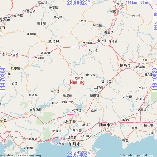
Nanling GPS coordinates[2]
23° 19' 19.74" North, 115° 24' 22.176" East
| Map corner | latitude | longitude |
|---|---|---|
| Upper-left | 23.96625°, | 114.70304° |
| Center: | 23.32215°, | 115.40616° |
| Lower-right: | 22.67492°, | 116.10929° |
| Map W x H: | 143.6×143.6 km | = 89.2×89.2mi |
| max Lat: | 53.31946° ⇑93% North |
| Nanling: | 23.32215° |
| min Lat: | ⇓7% South 18.22056° |
| min Long | Nanling | max Long |
| 75.07348° | 115.40616° | 134.28917° |
| W 56.4%⇐ | ⇒43.6% E |
Elevation
Elevation of Nanling is 344 m = 1129 ft, and this is 140.8 m = 462 ft below average elevation for this country.
| Max E: |
5622 m = 18445 ft | 33.9% |
| Avg. | 484.8 m = 1591 ft | |
| Nanling | 344 m = 1129 ft | |
Min E: |
-3 m = -10 ft | 66.1% |
See also: China elevation on elevation.city.
Geographical zone
Nanling is located in North Torrid zone (between Equator and Tropic of Cancer). Distance of this Northern Tropic circle is 12.7 km =7.9 mi to North.| Distance of | km | miles | from Nanling |
|---|---|---|---|
| North Pole | 7413.9 | 4606.8 | to North |
| Arctic Circle | 4808 | 2987.6 | to North |
| Tropic Cancer | 12.7 | 7.9 | to North |
| Equator | 2593.2 | 1611.3 | to South |


Nearby cities:
15 places around Nanling: (largest is in red/bold)
• Baokou
23.8 km =14.8 mi,  239°
239°
• Gaotan
18.6 km =11.6 mi,  214°
214°
• Hekou
25.9 km =16.1 mi,  127°
127°
• Hetian
25.7 km =16 mi,  95°
95°
• Huangqiang
19 km =11.8 mi,  176°
176°
• Jiushu
27.3 km =17 mi,  303°
303°
• Longwo
20.1 km =12.5 mi,  328°
328°
• Luoxi
22.5 km =14 mi,  74°
74°
• Mashan
18.2 km =11.3 mi,  250°
250°
• Nanwan
11 km =6.8 mi, 73°
• Pingdong
26.2 km =16.3 mi,  161°
161°
• Shanghu
20.2 km =12.6 mi,  111°
111°
• Shuidun
23.5 km =14.6 mi,  2°
2°
• Suqu
6.7 km =4.2 mi, 301°
• Xintian
21.2 km =13.2 mi,  136°
136°
Sources, notices
• [Note1] Compared only with cities in China existing in our database
• [Src1] Map data: © OpenStreetMap contributors (CC-BY-SA)
• [Src2] Other city data from geonames.org with taken over terms of usage.
• [Src3] Geographical zone / Annual Mean Temperature by Robert A. Rohde @ Wikipedia
