Baokou geodata
Baokou (Guangdong) is a seat of a fourth-order administrative division; located in China in Asia/Shanghai (GMT+8) time zone. In our database, there are 1268 cities with bigger population. Compared to other cities in China, 93.4% of cities are located further ↑North; 55.4% of cities are located further ←West and 53.2% of cities have lower elevation than Baokou. Note1


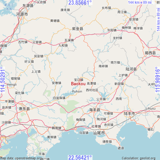
Baokou GPS coordinates[2]
23° 12' 43.092" North, 115° 12' 21.708" East
| Map corner | latitude | longitude |
|---|---|---|
| Upper-left | 23.85661°, | 114.50291° |
| Center: | 23.21197°, | 115.20603° |
| Lower-right: | 22.56421°, | 115.90916° |
| Map W x H: | 143.7×143.7 km | = 89.3×89.3mi |
| max Lat: | 53.31946° ⇑93.4% North |
| Baokou: | 23.21197° |
| min Lat: | ⇓6.6% South 18.22056° |
| min Long | Baokou | max Long |
| 75.07348° | 115.20603° | 134.28917° |
| W 55.4%⇐ | ⇒44.6% E |
Elevation
Elevation of Baokou is 190 m = 623 ft, and this is 294.8 m = 967 ft below average elevation for this country.
| Max E: |
5622 m = 18445 ft | 46.8% |
| Avg. | 484.8 m = 1591 ft | |
| Baokou | 190 m = 623 ft | |
Min E: |
-3 m = -10 ft | 53.2% |
See also: China elevation on elevation.city.
Geographical zone
Baokou is located in North Torrid zone (between Equator and Tropic of Cancer). Distance of this Northern Tropic circle is 25 km =15.5 mi to North.| Distance of | km | miles | from Baokou |
|---|---|---|---|
| North Pole | 7426.1 | 4614.4 | to North |
| Arctic Circle | 4820.2 | 2995.1 | to North |
| Tropic Cancer | 25 | 15.5 | to North |
| Equator | 2580.9 | 1603.7 | to South |


Nearby cities:
15 places around Baokou: (largest is in red/bold)
• Andun
20.8 km =12.9 mi,  261°
261°
• Baipenzhu
24 km =14.9 mi,  230°
230°
• Duozhu
33.4 km =20.8 mi, 232°
• Gaotan
10.5 km =6.5 mi,  107°
107°
• Gongping
25.5 km =15.8 mi,  131°
131°
• Haicheng
29.3 km =18.2 mi,  153°
153°
• Huangqiang
22.7 km =14.1 mi, 107°
• Jiushu
27.3 km =17 mi,  354°
354°
• Longwo
30.9 km =19.2 mi,  18°
18°
• Mashan
7.1 km =4.4 mi,  27°
27°
• Nanling
23.8 km =14.8 mi,  59°
59°
• Pingdong
31.5 km =19.6 mi, 113°
• Songkeng
30.1 km =18.7 mi, 263°
• Suqu
21.5 km =13.4 mi,  42°
42°
• Xin’an
10.2 km =6.3 mi,  188°
188°
Sources, notices
• [Note1] Compared only with cities in China existing in our database
• [Src1] Map data: © OpenStreetMap contributors (CC-BY-SA)
• [Src2] Other city data from geonames.org with taken over terms of usage.
• [Src3] Geographical zone / Annual Mean Temperature by Robert A. Rohde @ Wikipedia
