Nanwan geodata
Nanwan (Guangdong) is a seat of a fourth-order administrative division; located in China in Asia/Shanghai (GMT+8) time zone. In our database, there are 1268 cities with bigger population. Compared to other cities in China, 92.8% of cities are located further ↑North; 57.1% of cities are located further ←West and 75% of cities have lower elevation than Nanwan. Note1


Nanwan GPS coordinates[2]
23° 21' 1.584" North, 115° 30' 35.532" East
| Map corner | latitude | longitude |
|---|---|---|
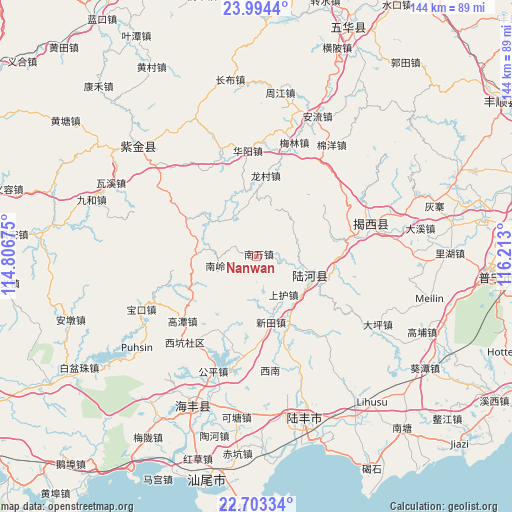
| Upper-left | 23.9944°, | 114.80675° |
| Center: | 23.35044°, | 115.50987° |
| Lower-right: | 22.70334°, | 116.213° |
| Map W x H: | 143.6×143.6 km | = 89.2×89.2mi |
| max Lat: | 53.31946° ⇑92.8% North |
| Nanwan: | 23.35044° |
| min Lat: | ⇓7.2% South 18.22056° |
| min Long | Nanwan | max Long |
| 75.07348° | 115.50987° | 134.28917° |
| W 57.1%⇐ | ⇒42.9% E |
Elevation
Elevation of Nanwan is 522 m = 1713 ft, and this is 37.2 m = 122 ft above average elevation for this country.
| Max E: |
5622 m = 18445 ft | 25% |
| Nanwan | 522 m 1713 ft | |
| Avg. | 484.8 m = 1591 ft | |
Min E: |
-3 m = -10 ft | 75% |
See also: China elevation on elevation.city.
Geographical zone
Nanwan is located in North Torrid zone (between Equator and Tropic of Cancer). Distance of this Northern Tropic circle is 9.6 km =6 mi to North.| Distance of | km | miles | from Nanwan |
|---|---|---|---|
| North Pole | 7410.7 | 4604.8 | to North |
| Arctic Circle | 4804.8 | 2985.6 | to North |
| Tropic Cancer | 9.6 | 6 | to North |
| Equator | 2596.3 | 1613.3 | to South |


Nearby cities:
15 places around Nanwan: (largest is in red/bold)
• Dongkeng
22.2 km =13.8 mi,  111°
111°
• Hekou
21.4 km =13.3 mi,  152°
152°
• Hetian
16 km =9.9 mi, 109°
• Huangqiang
24 km =14.9 mi,  202°
202°
• Longcun
22.6 km =14 mi,  5°
5°
• Longwo
25.4 km =15.8 mi,  303°
303°
• Luoxi
11.4 km =7.1 mi,  75°
75°
• Nanling
11 km =6.8 mi,  253°
253°
• Shanghu
13.4 km =8.3 mi,  142°
142°
• Shangsha
23.3 km =14.5 mi,  53°
53°
• Shuichun
23.6 km =14.7 mi,  99°
99°
• Shuidun
22.4 km =13.9 mi,  335°
335°
• Suqu
16.3 km =10.1 mi,  271°
271°
• Wuyun
28 km =17.4 mi, 79°
• Xintian
18.9 km =11.7 mi,  167°
167°
Sources, notices
• [Note1] Compared only with cities in China existing in our database
• [Src1] Map data: © OpenStreetMap contributors (CC-BY-SA)
• [Src2] Other city data from geonames.org with taken over terms of usage.
• [Src3] Geographical zone / Annual Mean Temperature by Robert A. Rohde @ Wikipedia
