Mailing geodata
Mailing (Henan) is a seat of a fourth-order administrative division; located in China in Asia/Shanghai (GMT+8) time zone. In our database, there are 1268 cities with bigger population. Compared to other cities in China, 69.1% of cities are located further ↓South; 53.4% of cities are located further →East and 64.1% of cities have higher elevation than Mailing. Note1


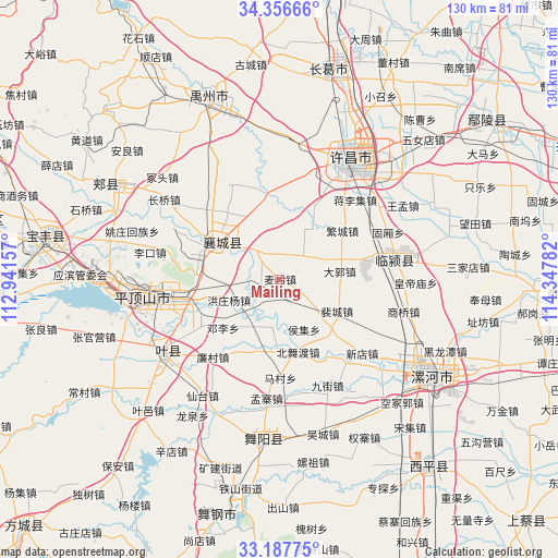
Mailing GPS coordinates[2]
33° 46' 27.12" North, 113° 38' 40.884" East
| Map corner | latitude | longitude |
|---|---|---|
| Upper-left | 34.35666°, | 112.94157° |
| Center: | 33.7742°, | 113.64469° |
| Lower-right: | 33.18775°, | 114.34782° |
| Map W x H: | 130×130 km | = 80.8×80.8mi |
| max Lat: | 53.31946° ⇑30.9% North |
| Mailing: | 33.7742° |
| min Lat: | ⇓69.1% South 18.22056° |
| min Long | Mailing | max Long |
| 75.07348° | 113.64469° | 134.28917° |
| W 46.6%⇐ | ⇒53.4% E |
Elevation
Elevation of Mailing is 77 m = 253 ft, and this is 407.8 m = 1338 ft below average elevation for this country.
| Max E: |
5622 m = 18445 ft | 64.1% |
| Avg. | 484.8 m = 1591 ft | |
| Mailing | 77 m = 253 ft | |
Min E: |
-3 m = -10 ft | 35.9% |
See also: China elevation on elevation.city.
Geographical zone
Mailing is located in North temperate zone (between Tropic of Cancer and the Arctic Circle). Distance of this Northern Tropic circle is 1149.4 km =714.2 mi to South.| Distance of | km | miles | from Mailing |
|---|---|---|---|
| North Pole | 6251.7 | 3884.6 | to North |
| Arctic Circle | 3645.8 | 2265.4 | to North |
| Tropic Cancer | 1149.4 | 714.2 | to South |
| Equator | 3755.3 | 2333.4 | to South |


Nearby cities:
15 places around Mailing: (largest is in red/bold)
• Beiwudu
17.6 km =10.9 mi,  165°
165°
• Cigou
8.7 km =5.4 mi,  318°
318°
• Daguo
14.1 km =8.8 mi,  82°
82°
• Dengli
17.4 km =10.8 mi,  229°
229°
• Dingying
4.4 km =2.7 mi,  240°
240°
• Fanhu
8.6 km =5.3 mi,  23°
23°
• Hongzhuangyang
12.8 km =8 mi,  247°
247°
• Houji
12.8 km =8 mi,  154°
154°
• Kuzhuang
16.3 km =10.1 mi,  331°
331°
• Peicheng
15.3 km =9.5 mi,  119°
119°
• Shantoudian
11.4 km =7.1 mi,  277°
277°
• Shuangmiao
14.9 km =9.3 mi,  356°
356°
• Xiangcheng Chengguanzhen
17.4 km =10.8 mi,  297°
297°
• Zhanbei
18.5 km =11.5 mi,  271°
271°
• Zhanghua
11.9 km =7.4 mi,  189°
189°
Sources, notices
• [Note1] Compared only with cities in China existing in our database
• [Src1] Map data: © OpenStreetMap contributors (CC-BY-SA)
• [Src2] Other city data from geonames.org with taken over terms of usage.
• [Src3] Geographical zone / Annual Mean Temperature by Robert A. Rohde @ Wikipedia
