Hongzhuangyang geodata
Hongzhuangyang (Henan) is a seat of a fourth-order administrative division; located in China in Asia/Shanghai (GMT+8) time zone. In our database, there are 1268 cities with bigger population. Compared to other cities in China, 68.8% of cities are located further ↓South; 54.2% of cities are located further →East and 63.5% of cities have higher elevation than Hongzhuangyang. Note1


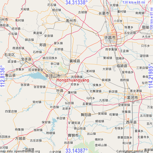
Hongzhuangyang GPS coordinates[2]
33° 43' 50.232" North, 113° 31' 0.192" East
| Map corner | latitude | longitude |
|---|---|---|
| Upper-left | 34.31338°, | 112.8136° |
| Center: | 33.73062°, | 113.51672° |
| Lower-right: | 33.14387°, | 114.21985° |
| Map W x H: | 130×130 km | = 80.8×80.8mi |
| max Lat: | 53.31946° ⇑31.2% North |
| Hongzhuangyang: | 33.73062° |
| min Lat: | ⇓68.8% South 18.22056° |
| min Long | Hongzhuangyang | max Long |
| 75.07348° | 113.51672° | 134.28917° |
| W 45.8%⇐ | ⇒54.2% E |
Elevation
Elevation of Hongzhuangyang is 80 m = 262 ft, and this is 404.8 m = 1328 ft below average elevation for this country.
| Max E: |
5622 m = 18445 ft | 63.5% |
| Avg. | 484.8 m = 1591 ft | |
| Hongzhuangyang | 80 m = 262 ft | |
Min E: |
-3 m = -10 ft | 36.5% |
See also: China elevation on elevation.city.
Geographical zone
Hongzhuangyang is located in North temperate zone (between Tropic of Cancer and the Arctic Circle). Distance of this Northern Tropic circle is 1144.6 km =711.2 mi to South.| Distance of | km | miles | from Hongzhuangyang |
|---|---|---|---|
| North Pole | 6256.6 | 3887.7 | to North |
| Arctic Circle | 3650.7 | 2268.4 | to North |
| Tropic Cancer | 1144.6 | 711.2 | to South |
| Equator | 3750.5 | 2330.5 | to South |


Nearby cities:
15 places around Hongzhuangyang: (largest is in red/bold)
• Cigou
12.9 km =8 mi,  28°
28°
• Dengli
6.7 km =4.2 mi,  191°
191°
• Dingying
8.4 km =5.2 mi,  71°
71°
• Donggaohuang
14.5 km =9 mi,  281°
281°
• Gongdian
10.7 km =6.6 mi,  224°
224°
• Liancun
13.9 km =8.6 mi,  196°
196°
• Mailing
12.8 km =8 mi, 67°
• Shantoudian
6.4 km =4 mi,  4°
4°
• Shilipu
18.6 km =11.6 mi,  334°
334°
• Shuizhai
12.3 km =7.6 mi,  168°
168°
• Xiangcheng Chengguanzhen
13.4 km =8.3 mi,  344°
344°
• Zhanbei
8.5 km =5.3 mi,  308°
308°
• Zhanghua
12 km =7.5 mi,  125°
125°
• Ziyun
12.8 km =8 mi,  320°
320°
• Zunhuadian
11.1 km =6.9 mi,  255°
255°
Sources, notices
• [Note1] Compared only with cities in China existing in our database
• [Src1] Map data: © OpenStreetMap contributors (CC-BY-SA)
• [Src2] Other city data from geonames.org with taken over terms of usage.
• [Src3] Geographical zone / Annual Mean Temperature by Robert A. Rohde @ Wikipedia
