Zhanghua geodata
Zhanghua (Henan) is a seat of a fourth-order administrative division; located in China in Asia/Shanghai (GMT+8) time zone. In our database, there are 1268 cities with bigger population. Compared to other cities in China, 68.6% of cities are located further ↓South; 53.5% of cities are located further →East and 63.9% of cities have higher elevation than Zhanghua. Note1


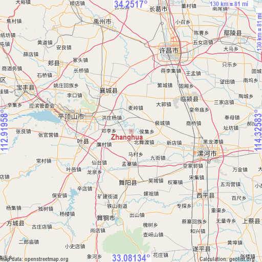
Zhanghua GPS coordinates[2]
33° 40' 6.636" North, 113° 37' 21.72" East
| Map corner | latitude | longitude |
|---|---|---|
| Upper-left | 34.2517°, | 112.91958° |
| Center: | 33.66851°, | 113.6227° |
| Lower-right: | 33.08134°, | 114.32583° |
| Map W x H: | 130.1×130.1 km | = 80.8×80.8mi |
| max Lat: | 53.31946° ⇑31.4% North |
| Zhanghua: | 33.66851° |
| min Lat: | ⇓68.6% South 18.22056° |
| min Long | Zhanghua | max Long |
| 75.07348° | 113.6227° | 134.28917° |
| W 46.5%⇐ | ⇒53.5% E |
Elevation
Elevation of Zhanghua is 78 m = 256 ft, and this is 406.8 m = 1335 ft below average elevation for this country.
| Max E: |
5622 m = 18445 ft | 63.9% |
| Avg. | 484.8 m = 1591 ft | |
| Zhanghua | 78 m = 256 ft | |
Min E: |
-3 m = -10 ft | 36.1% |
See also: China elevation on elevation.city.
Geographical zone
Zhanghua is located in North temperate zone (between Tropic of Cancer and the Arctic Circle). Distance of this Northern Tropic circle is 1137.7 km =706.9 mi to South.| Distance of | km | miles | from Zhanghua |
|---|---|---|---|
| North Pole | 6263.5 | 3892 | to North |
| Arctic Circle | 3657.6 | 2272.7 | to North |
| Tropic Cancer | 1137.7 | 706.9 | to South |
| Equator | 3743.6 | 2326.2 | to South |


Nearby cities:
15 places around Zhanghua: (largest is in red/bold)
• Beiwudu
8.3 km =5.2 mi,  129°
129°
• Dengli
11.1 km =6.9 mi,  271°
271°
• Dingying
9.7 km =6 mi,  349°
349°
• Gongdian
17.4 km =10.8 mi, 267°
• Hongzhuangyang
12 km =7.5 mi,  305°
305°
• Houji
7.6 km =4.7 mi,  88°
88°
• Jiangdian
16 km =9.9 mi,  167°
167°
• Liancun
15.2 km =9.4 mi,  245°
245°
• Macun
11.5 km =7.1 mi, 169°
• Mailing
11.9 km =7.4 mi,  9°
9°
• Mengzhai
14.1 km =8.8 mi,  185°
185°
• Peicheng
16 km =9.9 mi,  74°
74°
• Shantoudian
16.2 km =10.1 mi,  325°
325°
• Shuizhai
9 km =5.6 mi,  234°
234°
• Taiwei
13.2 km =8.2 mi,  109°
109°
Sources, notices
• [Note1] Compared only with cities in China existing in our database
• [Src1] Map data: © OpenStreetMap contributors (CC-BY-SA)
• [Src2] Other city data from geonames.org with taken over terms of usage.
• [Src3] Geographical zone / Annual Mean Temperature by Robert A. Rohde @ Wikipedia
