Aotou geodata
Aotou (Guangdong) is a seat of a fourth-order administrative division; located in China in Asia/Urumqi (GMT+6) time zone. In our database, there are 1268 cities with bigger population. Compared to other cities in China, 98% of cities are located further ↑North; 67.6% of cities are located further →East and 82.4% of cities have higher elevation than Aotou. Note1


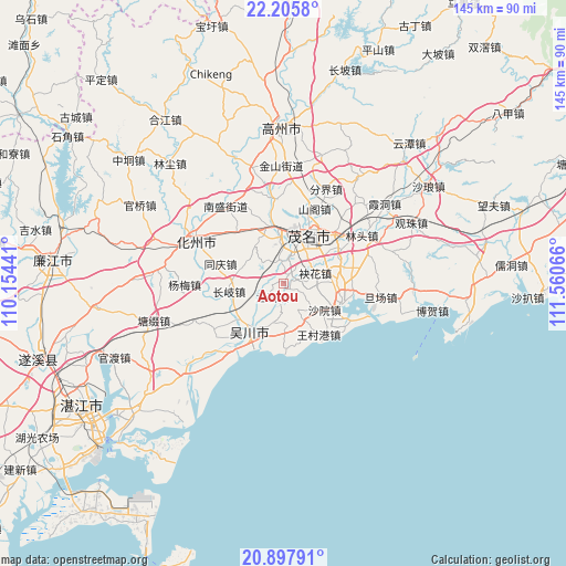
Aotou GPS coordinates[2]
21° 33' 11.988" North, 110° 51' 27.108" East
| Map corner | latitude | longitude |
|---|---|---|
| Upper-left | 22.2058°, | 110.15441° |
| Center: | 21.55333°, | 110.85753° |
| Lower-right: | 20.89791°, | 111.56066° |
| Map W x H: | 145.4×145.4 km | = 90.3×90.3mi |
| max Lat: | 53.31946° ⇑98% North |
| Aotou: | 21.55333° |
| min Lat: | ⇓2% South 18.22056° |
| min Long | Aotou | max Long |
| 75.07348° | 110.85753° | 134.28917° |
| W 32.4%⇐ | ⇒67.6% E |
Elevation
Elevation of Aotou is 21 m = 69 ft, and this is 463.8 m = 1522 ft below average elevation for this country.
| Max E: |
5622 m = 18445 ft | 82.4% |
| Avg. | 484.8 m = 1591 ft | |
| Aotou | 21 m = 69 ft | |
Min E: |
-3 m = -10 ft | 17.6% |
See also: China elevation on elevation.city.
Geographical zone
Aotou is located in North Torrid zone (between Equator and Tropic of Cancer). Distance of this Northern Tropic circle is 209.4 km =130.1 mi to North.| Distance of | km | miles | from Aotou |
|---|---|---|---|
| North Pole | 7610.6 | 4729 | to North |
| Arctic Circle | 5004.7 | 3109.8 | to North |
| Tropic Cancer | 209.4 | 130.1 | to North |
| Equator | 2396.5 | 1489.1 | to South |


Nearby cities:
15 places around Aotou: (largest is in red/bold)
• Bopu
13.3 km =8.3 mi,  209°
209°
• Changqi
14.1 km =8.8 mi,  261°
261°
• Gaodi
14.5 km =9 mi,  115°
115°
• Gaoshan
12 km =7.5 mi,  20°
20°
• Hedong
14.6 km =9.1 mi,  29°
29°
• Lanshi
5.2 km =3.2 mi,  217°
217°
• Maoming
11.6 km =7.2 mi, 22°
• Meihua
8.5 km =5.3 mi,  70°
70°
• Qianshui
11.5 km =7.1 mi,  288°
288°
• Qijing
14.2 km =8.8 mi,  83°
83°
• Tanba
12 km =7.5 mi,  181°
181°
• Wuchuan
14.3 km =8.9 mi, 221°
• Xiaoliang
7.5 km =4.7 mi,  152°
152°
• Xinpo
12.6 km =7.8 mi, 16°
• Zhencheng
6.4 km =4 mi,  351°
351°
Sources, notices
• [Note1] Compared only with cities in China existing in our database
• [Src1] Map data: © OpenStreetMap contributors (CC-BY-SA)
• [Src2] Other city data from geonames.org with taken over terms of usage.
• [Src3] Geographical zone / Annual Mean Temperature by Robert A. Rohde @ Wikipedia
