Mazhuang geodata
Mazhuang (Tianjin) is a populated place; located in China in Asia/Shanghai (GMT+8) time zone. With population of 1,487 people, there are 1091 cities with bigger population in this country. Compared to other cities in China, 83.8% of cities are located further ↓South; 66.6% of cities are located further ←West and 92.7% of cities have higher elevation than Mazhuang. Note1


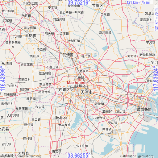
Mazhuang GPS coordinates[2]
39° 12' 34.092" North, 117° 7' 59.196" East
| Map corner | latitude | longitude |
|---|---|---|
| Upper-left | 39.75216°, | 116.42999° |
| Center: | 39.20947°, | 117.13311° |
| Lower-right: | 38.66255°, | 117.83624° |
| Map W x H: | 121.2×121.2 km | = 75.3×75.3mi |
| max Lat: | 53.31946° ⇑16.2% North |
| Mazhuang: | 39.20947° |
| min Lat: | ⇓83.8% South 18.22056° |
| min Long | Mazhuang | max Long |
| 75.07348° | 117.13311° | 134.28917° |
| W 66.6%⇐ | ⇒33.4% E |
Elevation
Elevation of Mazhuang is 8 m = 26 ft, and this is 476.8 m = 1564 ft below average elevation for this country.
| Max E: |
5622 m = 18445 ft | 92.7% |
| Avg. | 484.8 m = 1591 ft | |
| Mazhuang | 8 m = 26 ft | |
Min E: |
-3 m = -10 ft | 7.3% |
See also: China elevation on elevation.city.
Geographical zone
Mazhuang is located in North temperate zone (between Tropic of Cancer and the Arctic Circle). Distance of this Northern Tropic circle is 1753.8 km =1089.8 mi to South.| Distance of | km | miles | from Mazhuang |
|---|---|---|---|
| North Pole | 5647.4 | 3509.1 | to North |
| Arctic Circle | 3041.5 | 1889.9 | to North |
| Tropic Cancer | 1753.8 | 1089.8 | to South |
| Equator | 4359.7 | 2709 | to South |


Nearby cities:
15 places around Mazhuang: (largest is in red/bold)
• Beicang
3.1 km =1.9 mi,  342°
342°
• Dingzigu
4.5 km =2.8 mi,  151°
151°
• Guoyuan Xincun
1.4 km =0.9 mi,  349°
349°
• Hanjiashu
5.7 km =3.5 mi,  244°
244°
• Liu’anzhuang
6.5 km =4 mi,  59°
59°
• Nancang
0.7 km =0.4 mi,  155°
155°
• Shaogongzhuang
6.3 km =3.9 mi, 162°
• Shuangjie
6.5 km =4 mi,  331°
331°
• Tiedonglu
6 km =3.7 mi,  111°
111°
• Wangqinzhuang
4.3 km =2.7 mi,  300°
300°
• Xianyang Beilu
2.9 km =1.8 mi,  168°
168°
• Xigu
5.9 km =3.7 mi, 148°
• Xinkaihe
5.4 km =3.4 mi,  134°
134°
• Xiyuzhuang
5.2 km =3.2 mi, 156°
• Yixingfu
6.8 km =4.2 mi,  99°
99°
Sources, notices
• [Note1] Compared only with cities in China existing in our database
• [Src1] Map data: © OpenStreetMap contributors (CC-BY-SA)
• [Src2] Other city data from geonames.org with taken over terms of usage.
• [Src3] Geographical zone / Annual Mean Temperature by Robert A. Rohde @ Wikipedia
