Mayang geodata
Mayang (Hubei) is a seat of a fourth-order administrative division; located in China in Asia/Shanghai (GMT+8) time zone. In our database, there are 1268 cities with bigger population. Compared to other cities in China, 50.1% of cities are located further ↑North; 55.8% of cities are located further →East and 76.7% of cities have higher elevation than Mayang. Note1


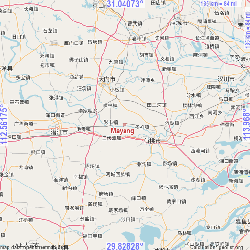
Mayang GPS coordinates[2]
30° 26' 11.004" North, 113° 15' 53.532" East
| Map corner | latitude | longitude |
|---|---|---|
| Upper-left | 31.04073°, | 112.56175° |
| Center: | 30.43639°, | 113.26487° |
| Lower-right: | 29.82828°, | 113.968° |
| Map W x H: | 134.8×134.8 km | = 83.8×83.8mi |
| max Lat: | 53.31946° ⇑50.1% North |
| Mayang: | 30.43639° |
| min Lat: | ⇓49.9% South 18.22056° |
| min Long | Mayang | max Long |
| 75.07348° | 113.26487° | 134.28917° |
| W 44.2%⇐ | ⇒55.8% E |
Elevation
Elevation of Mayang is 33 m = 108 ft, and this is 451.8 m = 1482 ft below average elevation for this country.
| Max E: |
5622 m = 18445 ft | 76.7% |
| Avg. | 484.8 m = 1591 ft | |
| Mayang | 33 m = 108 ft | |
Min E: |
-3 m = -10 ft | 23.3% |
See also: China elevation on elevation.city.
Geographical zone
Mayang is located in North temperate zone (between Tropic of Cancer and the Arctic Circle). Distance of this Northern Tropic circle is 778.3 km =483.6 mi to South.| Distance of | km | miles | from Mayang |
|---|---|---|---|
| North Pole | 6622.9 | 4115.3 | to North |
| Arctic Circle | 4017 | 2496 | to North |
| Tropic Cancer | 778.3 | 483.6 | to South |
| Equator | 3384.2 | 2102.8 | to South |


Nearby cities:
15 places around Mayang: (largest is in red/bold)
• Duoxiang
9.2 km =5.7 mi,  96°
96°
• Ganhe
16.2 km =10.1 mi,  113°
113°
• Ganyi
16.3 km =10.1 mi,  42°
42°
• Guohe
21.3 km =13.2 mi,  173°
173°
• Henglin
13.5 km =8.4 mi,  323°
323°
• Huchang
7.4 km =4.6 mi,  152°
152°
• Lijiazui
21.6 km =13.4 mi,  291°
291°
• Longhuashan
19.5 km =12.1 mi, 111°
• Mawan
16.6 km =10.3 mi,  21°
21°
• Pengshi
8.1 km =5 mi,  283°
283°
• Sanfutan
9.5 km =5.9 mi,  224°
224°
• Shazui
19.4 km =12.1 mi,  116°
116°
• Tian’erhe
20.2 km =12.6 mi,  56°
56°
• Xiantao
18.6 km =11.6 mi, 113°
• Xiaoban
20 km =12.4 mi,  346°
346°
Sources, notices
• [Note1] Compared only with cities in China existing in our database
• [Src1] Map data: © OpenStreetMap contributors (CC-BY-SA)
• [Src2] Other city data from geonames.org with taken over terms of usage.
• [Src3] Geographical zone / Annual Mean Temperature by Robert A. Rohde @ Wikipedia
