Sanfutan geodata
Sanfutan (Hubei) is a seat of a fourth-order administrative division; located in China in Asia/Shanghai (GMT+8) time zone. In our database, there are 1268 cities with bigger population. Compared to other cities in China, 50.6% of cities are located further ↑North; 56.4% of cities are located further →East and 77.7% of cities have higher elevation than Sanfutan. Note1


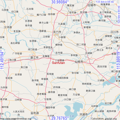
Sanfutan GPS coordinates[2]
30° 22' 34.068" North, 113° 11' 42.216" East
| Map corner | latitude | longitude |
|---|---|---|
| Upper-left | 30.98084°, | 112.49194° |
| Center: | 30.37613°, | 113.19506° |
| Lower-right: | 29.76765°, | 113.89819° |
| Map W x H: | 134.9×134.9 km | = 83.8×83.8mi |
| max Lat: | 53.31946° ⇑50.6% North |
| Sanfutan: | 30.37613° |
| min Lat: | ⇓49.4% South 18.22056° |
| min Long | Sanfutan | max Long |
| 75.07348° | 113.19506° | 134.28917° |
| W 43.6%⇐ | ⇒56.4% E |
Elevation
Elevation of Sanfutan is 31 m = 102 ft, and this is 453.8 m = 1489 ft below average elevation for this country.
| Max E: |
5622 m = 18445 ft | 77.7% |
| Avg. | 484.8 m = 1591 ft | |
| Sanfutan | 31 m = 102 ft | |
Min E: |
-3 m = -10 ft | 22.3% |
See also: China elevation on elevation.city.
Geographical zone
Sanfutan is located in North temperate zone (between Tropic of Cancer and the Arctic Circle). Distance of this Northern Tropic circle is 771.6 km =479.4 mi to South.| Distance of | km | miles | from Sanfutan |
|---|---|---|---|
| North Pole | 6629.6 | 4119.4 | to North |
| Arctic Circle | 4023.7 | 2500.2 | to North |
| Tropic Cancer | 771.6 | 479.4 | to South |
| Equator | 3377.5 | 2098.7 | to South |


Nearby cities:
15 places around Sanfutan: (largest is in red/bold)
• Chenchang
18.9 km =11.7 mi,  216°
216°
• Duoxiang
16.8 km =10.4 mi,  70°
70°
• Ganhe
21.5 km =13.4 mi,  89°
89°
• Guohe
17.1 km =10.6 mi,  147°
147°
• Henglin
17.6 km =10.9 mi,  355°
355°
• Huchang
10.2 km =6.3 mi, 89°
• Lijiazui
19.9 km =12.4 mi,  317°
317°
• Maozui
16.4 km =10.2 mi,  286°
286°
• Mayang
9.5 km =5.9 mi,  44°
44°
• Mianchenghuizu
19.9 km =12.4 mi,  171°
171°
• Pengshi
8.6 km =5.3 mi,  352°
352°
• Tonghaikou
20.4 km =12.7 mi,  192°
192°
• Xiantao
23.8 km =14.8 mi, 91°
• Zhanggou
22.1 km =13.7 mi,  129°
129°
• Zhengchang
20.6 km =12.8 mi,  308°
308°
Sources, notices
• [Note1] Compared only with cities in China existing in our database
• [Src1] Map data: © OpenStreetMap contributors (CC-BY-SA)
• [Src2] Other city data from geonames.org with taken over terms of usage.
• [Src3] Geographical zone / Annual Mean Temperature by Robert A. Rohde @ Wikipedia
