Mawang geodata
Mawang (Shaanxi) is a seat of a fourth-order administrative division; located in China in Asia/Shanghai (GMT+8) time zone. In our database, there are 1268 cities with bigger population. Compared to other cities in China, 71.1% of cities are located further ↓South; 77.6% of cities are located further →East and 69.5% of cities have lower elevation than Mawang. Note1


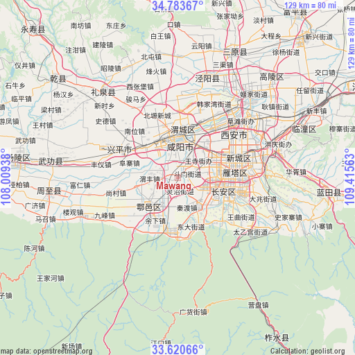
Mawang GPS coordinates[2]
34° 12' 15.012" North, 108° 42' 45" East
| Map corner | latitude | longitude |
|---|---|---|
| Upper-left | 34.78367°, | 108.00938° |
| Center: | 34.20417°, | 108.7125° |
| Lower-right: | 33.62066°, | 109.41563° |
| Map W x H: | 129.3×129.3 km | = 80.3×80.3mi |
| max Lat: | 53.31946° ⇑28.9% North |
| Mawang: | 34.20417° |
| min Lat: | ⇓71.1% South 18.22056° |
| min Long | Mawang | max Long |
| 75.07348° | 108.7125° | 134.28917° |
| W 22.4%⇐ | ⇒77.6% E |
Elevation
Elevation of Mawang is 401 m = 1316 ft, and this is 83.8 m = 275 ft below average elevation for this country.
| Max E: |
5622 m = 18445 ft | 30.5% |
| Avg. | 484.8 m = 1591 ft | |
| Mawang | 401 m = 1316 ft | |
Min E: |
-3 m = -10 ft | 69.5% |
See also: China elevation on elevation.city.
Geographical zone
Mawang is located in North temperate zone (between Tropic of Cancer and the Arctic Circle). Distance of this Northern Tropic circle is 1197.2 km =743.9 mi to South.| Distance of | km | miles | from Mawang |
|---|---|---|---|
| North Pole | 6203.9 | 3854.9 | to North |
| Arctic Circle | 3598 | 2235.7 | to North |
| Tropic Cancer | 1197.2 | 743.9 | to South |
| Equator | 3803.1 | 2363.1 | to South |


Nearby cities:
15 places around Mawang: (largest is in red/bold)
• Cangyou
7 km =4.3 mi,  229°
229°
• Chenyangzhai
12.9 km =8 mi,  357°
357°
• Dawang
5.6 km =3.5 mi,  268°
268°
• Diaotai
9.4 km =5.8 mi,  345°
345°
• Doumen
4 km =2.5 mi,  68°
68°
• Gaoqiao
4.4 km =2.7 mi, 351°
• Qindu
11.8 km =7.3 mi,  162°
162°
• Tianfu
12.8 km =8 mi,  301°
301°
• Wangsi
9.1 km =5.7 mi,  55°
55°
• Weibin
13.8 km =8.6 mi,  333°
333°
• Weifeng
9.2 km =5.7 mi,  263°
263°
• Wuzhu
11.3 km =7 mi,  206°
206°
• Xiliu
9.4 km =5.8 mi,  129°
129°
• Xinglong
13 km =8.1 mi, 132°
• Yuhuazhai
13.4 km =8.3 mi,  79°
79°
Sources, notices
• [Note1] Compared only with cities in China existing in our database
• [Src1] Map data: © OpenStreetMap contributors (CC-BY-SA)
• [Src2] Other city data from geonames.org with taken over terms of usage.
• [Src3] Geographical zone / Annual Mean Temperature by Robert A. Rohde @ Wikipedia
