Liushikou geodata
Liushikou (Zhejiang) is a seat of a fourth-order administrative division; located in China in Asia/Shanghai (GMT+8) time zone. In our database, there are 1268 cities with bigger population. Compared to other cities in China, 61.9% of cities are located further ↑North; 84.1% of cities are located further ←West and 60.9% of cities have higher elevation than Liushikou. Note1


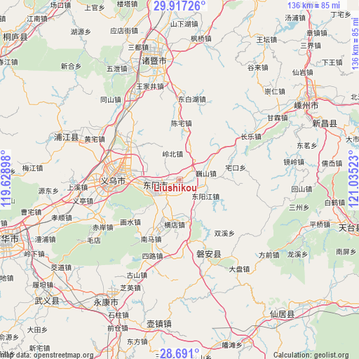
Liushikou GPS coordinates[2]
29° 18' 21.492" North, 120° 19' 55.56" East
| Map corner | latitude | longitude |
|---|---|---|
| Upper-left | 29.91726°, | 119.62898° |
| Center: | 29.30597°, | 120.3321° |
| Lower-right: | 28.691°, | 121.03523° |
| Map W x H: | 136.3×136.3 km | = 84.7×84.7mi |
| max Lat: | 53.31946° ⇑61.9% North |
| Liushikou: | 29.30597° |
| min Lat: | ⇓38.1% South 18.22056° |
| min Long | Liushikou | max Long |
| 75.07348° | 120.3321° | 134.28917° |
| W 84.1%⇐ | ⇒15.9% E |
Elevation
Elevation of Liushikou is 93 m = 305 ft, and this is 391.8 m = 1285 ft below average elevation for this country.
| Max E: |
5622 m = 18445 ft | 60.9% |
| Avg. | 484.8 m = 1591 ft | |
| Liushikou | 93 m = 305 ft | |
Min E: |
-3 m = -10 ft | 39.1% |
See also: China elevation on elevation.city.
Geographical zone
Liushikou is located in North temperate zone (between Tropic of Cancer and the Arctic Circle). Distance of this Northern Tropic circle is 652.6 km =405.5 mi to South.| Distance of | km | miles | from Liushikou |
|---|---|---|---|
| North Pole | 6748.5 | 4193.3 | to North |
| Arctic Circle | 4142.7 | 2574.2 | to North |
| Tropic Cancer | 652.6 | 405.5 | to South |
| Equator | 3258.5 | 2024.7 | to South |


Nearby cities:
15 places around Liushikou: (largest is in red/bold)
• Beijiang
5.5 km =3.4 mi,  130°
130°
• Chengdong
2.3 km =1.4 mi,  202°
202°
• Dongyang
11.2 km =7 mi,  247°
247°
• Geshan
10.4 km =6.5 mi,  101°
101°
• Guozhai
11.3 km =7 mi,  146°
146°
• Hengdian
16.7 km =10.4 mi,  185°
185°
• Huailu
6.4 km =4 mi,  49°
49°
• Huxi
15.2 km =9.4 mi,  157°
157°
• Jiangbei
9.7 km =6 mi,  266°
266°
• Lingbeizhou
10.5 km =6.5 mi,  344°
344°
• Weishan
10.3 km =6.4 mi,  74°
74°
• Wuning
11.1 km =6.9 mi,  241°
241°
• Xiachengli
13.9 km =8.6 mi,  57°
57°
• Xichou
12.3 km =7.6 mi,  123°
123°
• Zuocun
16.2 km =10.1 mi,  82°
82°
Sources, notices
• [Note1] Compared only with cities in China existing in our database
• [Src1] Map data: © OpenStreetMap contributors (CC-BY-SA)
• [Src2] Other city data from geonames.org with taken over terms of usage.
• [Src3] Geographical zone / Annual Mean Temperature by Robert A. Rohde @ Wikipedia
