Dongyang geodata
Dongyang (Zhejiang) is a seat of a third-order administrative division; located in China in Asia/Shanghai (GMT+8) time zone. With population of 130,387 people, there are 336 cities with bigger population in this country. Compared to other cities in China, 62.4% of cities are located further ↑North; 83.4% of cities are located further ←West and 60.3% of cities have higher elevation than Dongyang. Note1


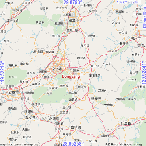
Dongyang GPS coordinates[2]
29° 16' 4.008" North, 120° 13' 31.008" East
| Map corner | latitude | longitude |
|---|---|---|
| Upper-left | 29.8793°, | 119.52216° |
| Center: | 29.26778°, | 120.22528° |
| Lower-right: | 28.65258°, | 120.92841° |
| Map W x H: | 136.4×136.4 km | = 84.8×84.8mi |
| max Lat: | 53.31946° ⇑62.4% North |
| Dongyang: | 29.26778° |
| min Lat: | ⇓37.6% South 18.22056° |
| min Long | Dongyang | max Long |
| 75.07348° | 120.22528° | 134.28917° |
| W 83.4%⇐ | ⇒16.6% E |
Elevation
Elevation of Dongyang is 97 m = 318 ft, and this is 387.8 m = 1272 ft below average elevation for this country.
| Max E: |
5622 m = 18445 ft | 60.3% |
| Avg. | 484.8 m = 1591 ft | |
| Dongyang | 97 m = 318 ft | |
Min E: |
-3 m = -10 ft | 39.7% |
See also: Dongyang elevation on elevation.city.
Geographical zone
Dongyang is located in North temperate zone (between Tropic of Cancer and the Arctic Circle). Distance of this Northern Tropic circle is 648.4 km =402.9 mi to South.| Distance of | km | miles | from Dongyang |
|---|---|---|---|
| North Pole | 6752.8 | 4196 | to North |
| Arctic Circle | 4146.9 | 2576.8 | to North |
| Tropic Cancer | 648.4 | 402.9 | to South |
| Equator | 3254.3 | 2022.1 | to South |


Nearby cities:
15 places around Dongyang: (largest is in red/bold)
• Beijiang
14.6 km =9.1 mi,  87°
87°
• Chengdong
9.7 km =6 mi,  77°
77°
• Guozhai
17.3 km =10.7 mi,  107°
107°
• Hengdian
15.1 km =9.4 mi,  144°
144°
• Huailu
17.3 km =10.7 mi,  61°
61°
• Huangtianfan
14.1 km =8.8 mi,  217°
217°
• Huaxi
10.3 km =6.4 mi, 218°
• Huxi
18.8 km =11.7 mi,  121°
121°
• Jiangbei
3.7 km =2.3 mi,  10°
10°
• Lingbeizhou
16.2 km =10.1 mi,  27°
27°
• Liushikou
11.2 km =7 mi,  67°
67°
• Nanshi
13.2 km =8.2 mi,  178°
178°
• Quanfu
18.2 km =11.3 mi, 181°
• Wuning
1.1 km =0.7 mi,  150°
150°
• Yiwu
15.3 km =9.5 mi,  290°
290°
Sources, notices
• [Note1] Compared only with cities in China existing in our database
• [Src1] Map data: © OpenStreetMap contributors (CC-BY-SA)
• [Src2] Other city data from geonames.org with taken over terms of usage.
• [Src3] Geographical zone / Annual Mean Temperature by Robert A. Rohde @ Wikipedia
