Hengdian geodata
Hengdian (Zhejiang) is a seat of a fourth-order administrative division; located in China in Asia/Shanghai (GMT+8) time zone. In our database, there are 1268 cities with bigger population. Compared to other cities in China, 63.7% of cities are located further ↑North; 84% of cities are located further ←West and 54.9% of cities have higher elevation than Hengdian. Note1


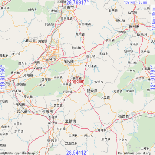
Hengdian GPS coordinates[2]
29° 9' 25.128" North, 120° 18' 53.208" East
| Map corner | latitude | longitude |
|---|---|---|
| Upper-left | 29.76917°, | 119.61166° |
| Center: | 29.15698°, | 120.31478° |
| Lower-right: | 28.54112°, | 121.01791° |
| Map W x H: | 136.5×136.5 km | = 84.8×84.8mi |
| max Lat: | 53.31946° ⇑63.7% North |
| Hengdian: | 29.15698° |
| min Lat: | ⇓36.3% South 18.22056° |
| min Long | Hengdian | max Long |
| 75.07348° | 120.31478° | 134.28917° |
| W 84%⇐ | ⇒16% E |
Elevation
Elevation of Hengdian is 132 m = 433 ft, and this is 352.8 m = 1157 ft below average elevation for this country.
| Max E: |
5622 m = 18445 ft | 54.9% |
| Avg. | 484.8 m = 1591 ft | |
| Hengdian | 132 m = 433 ft | |
Min E: |
-3 m = -10 ft | 45.1% |
See also: China elevation on elevation.city.
Geographical zone
Hengdian is located in North temperate zone (between Tropic of Cancer and the Arctic Circle). Distance of this Northern Tropic circle is 636 km =395.2 mi to South.| Distance of | km | miles | from Hengdian |
|---|---|---|---|
| North Pole | 6765.1 | 4203.6 | to North |
| Arctic Circle | 4159.2 | 2584.4 | to North |
| Tropic Cancer | 636 | 395.2 | to South |
| Equator | 3242 | 2014.5 | to South |


Nearby cities:
15 places around Hengdian: (largest is in red/bold)
• Anwen
16.1 km =10 mi,  132°
132°
• Beijiang
14.3 km =8.9 mi,  24°
24°
• Chengdong
14.4 km =8.9 mi,  3°
3°
• Dongyang
15.1 km =9.4 mi,  324°
324°
• Fangjun
11.7 km =7.3 mi,  215°
215°
• Guozhai
10.6 km =6.6 mi,  47°
47°
• Huaxi
15.7 km =9.8 mi,  285°
285°
• Huxi
7.8 km =4.8 mi,  71°
71°
• Mazhai
8.7 km =5.4 mi,  145°
145°
• Nanshi
8.3 km =5.2 mi,  263°
263°
• Qianxiang
12.7 km =7.9 mi,  180°
180°
• Quanfu
10.9 km =6.8 mi,  237°
237°
• Sanlian
13.1 km =8.1 mi,  166°
166°
• Wuning
13.9 km =8.6 mi, 324°
• Xichou
15.4 km =9.6 mi, 50°
Sources, notices
• [Note1] Compared only with cities in China existing in our database
• [Src1] Map data: © OpenStreetMap contributors (CC-BY-SA)
• [Src2] Other city data from geonames.org with taken over terms of usage.
• [Src3] Geographical zone / Annual Mean Temperature by Robert A. Rohde @ Wikipedia
